Showing posts with label waterfront. Show all posts

Friday, March 20, 2020

Toronto Waterfront or Harbourfront

Harbour Plaza Residences (65 and 69 story condominium towers) at center of photo


The CN Tower (at center right) is Toronto's most well-known landmark.


Photos taken in October 2017

To access the Toronto Waterfront, also called Harbourfront, requires passing under the monstrously ugly Gardiner Expressway, completed in 1963. We had our own eyesore, elevated highway in my hometown of Seattle, the Alaskan Way Viaduct, along the waterfront from 1953 until its demolition in 2019. They were & are still common in many US cities. Gardiner Expressway has been the subject of several proposals to demolish it as part of downtown waterfront revitalization efforts. I hope that happens.

The first thing I noticed about the Toronto Waterfront was the many residential towers as high as 70 floors. They were both impressive & overwhelming. The next thing I noticed was the string of parks along the water. Some were grassy & some had trees, while others were paved with concrete & boardwalk, or covered in sand. There were restaurants, shops, art galleries, water taxis & rental canoes. The waterfront was very interesting & dynamic. It had certainly been beautified, even if was not entirely beautiful. I enjoyed it.

More about the Waterfront
Harbourfront is the area along the Toronto waterfront extending from Bathurst Street to Yonge Street along Queens Quay. Its northern boundary is the Gardiner Expressway. Federal government lands to the south of Queen's Quay include a community center, Toronto Fire Department station, various boating uses, parkland & Harbourfront Centre. To the north of Queen's Quay, all of the industrial lands along the street have been replaced with condominium towers.

Harbourfront Centre, filled with galleries & performance spaces, is located at the foot of Lower Simcoe Street. There are 4 craft studios: ceramics, glass, metal and textiles. The studios began in 1974, providing new craft artists with subsidized work spaces at the beginning of their careers. Harbourfront hosts arts & cultural events every summer, including craft fairs, theater & dance performances, & concerts. Queen's Quay Terminal, next to Harbourfront Centre, is a former warehouse converted into a mixed-use building including stores & restaurants, commercial office space & condominiums.

Some History of the Waterfront
Toronto's harbor was used from the beginning of settlement for shipping & industry. The Town of York was founded west of the Don River, along the waterfront. At that time, the water's edge was where Front Street is now located. The shallow waters of Lake Ontario south of Front Street were covered with landfill, creating piers & room for industrial development.

The Harbourfront project was announced in 1972. It used industrial port lands from York Street west to Bathurst Street, south of Queen's Quay to create a cultural & residential district similar to the Granville Island in Vancouver. The federal government converted industrial land to an area with art galleries, performance spaces, boating areas & parks. The surrounding neighborhood was converted from industrial use to condominium towers by private developers.

There was a major reconstruction of Queen's Quay beginning in 2012. Two car lanes south of the streetcar tracks were eliminated between Spadina Avenue & York Street to extend Harbourfront parkland to the edge of the streetcar tracks. The Martin Goodman Trail (a bicycle path), two rows of trees, benches & a wider pedestrian space were installed there.

Friday, May 3, 2019

Lyon Confluence


Jardin d'Erevan


Jardin Aquatique Ouagadougou

Jardin Aquatique Jean Couty

Place Nautique

Promenade du quai Rambaud

Promenade du quai Rambaud, Rivière La Saône

Click here for more photos of Lyon Confluence.
Click here for video of Place Nautique.

Lyon Confluence is a remarkable example of urban renewal at the old Port of Lyon. It is comparable to South Lake Union in Seattle, the Pearl District in Portland OR & other redeveloped urban industrial sites. The architecture here is bolder than in any other place I have seen.  This was the part of Lyon I found most attractive & interesting.  When it’s done, Lyon Confluence will double the size of the central residential area of Lyon.  The waterfront is more accessible here than in other parts of Lyon, which has grown up along the banks of the Rhône and Saône Rivers since the arrival of the Romans.  Place Nautique brings the Saône River to the center of the residential & commercial area with apartment buildings on one side & a shopping mall on the other.  Most of Lyon Confluence is less than 400 yards from water.  Parc de la Saône was built along the river, replacing a busy road with a 35-acre park designed by landscape architect Michel Desvigne.  It has separate paths for cyclists & pedestrians along with gardens & ponds that encourage & mimic nature.  Eventually it will be possible to walk or bike for miles along the Saône River, around the tip of the Confluence & then along the Rhône River.  Discussion of the redevelopment began in 1998 & work began in 2003.  Lyon  Confluence is expected to be completed in 2020.

Friday, March 1, 2019

Vallon des Auffes Marseille France

Plage (anse) des Catalans


Monument aux morts de la Porte d'Orient


Vallon des Auffes. Photos taken in February 2017

The Vallon des Auffes in Marseille France is a very charming piece of urban landscape with a small & enclosed harbor.  It is similar to, but much smaller than, the Vieux Port de Marseille.  The word vallon means 'small valley' & auffe is a species of grass (Stipa tenacissima) used to make rope, mats & fishing nets. Many small fishing boats gather here.  The harbor is surrounded by dense housing of many styles & sizes.  I thought the mid-rise residential towers were out of scale.  But after reviewing the photos, I think they make sense.  They are located far enough away not to overwhelm & near enough to provide a picturesque view for their residents.  The elevated bridge of the Corniche du Président John Fitzgerald Kennedy is imposing, yet elegant with its stone facing & 19th-century style.  I walked here from my hotel on la Canebière along the south side of the Vieux Port, then up to the jardin du Pharo, then along the coastline on the corniche, which has ample sidewalks.  I recommend this route.  The jardin du Pharo provides an excellent view of the Vieux Port.  I saw men playing volleyball at the plage (anse) des Catalans. This short bit of coast is lovely.  The monument aux morts de la Porte d'Orient (dedicated in 1927) is impressive & austere in its Art Deco style.  The Vallon des Auffes is quite popular with tourists.  But there were very few people out on the windy & chilly February day I was there.  It felt real in a way that a place with hundreds of tourists never can.  Please compare this small harbor with other waterfront posts on this blog.  Waterfronts are uniquely urban landscapes.

Friday, December 7, 2018

Vieux Port Marseille France

Northern Bank of the Vieux Port


Eastern Bank of the Vieux Port

Fort Saint-Jean at the entrance to the Vieux Port

Northern Bank of the Vieux Port


Museum of the Roman Docks

La maison Diamantée (ancien hôtel de Saboulin Bollena) Photos taken February & March 2017

Click here for more photos of Marseille.

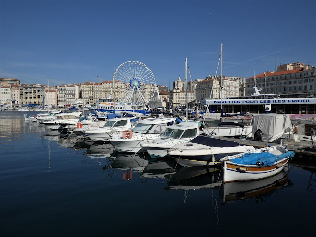
The Vieux (Old) Port is the visual centerpiece of Marseille, a grand & captivating sight. The most striking feature its almost complete enclosure by the beautiful City of Marseille. It is certainly the main tourist attraction & center of tourist activity. Marseille was founded as a trading port in 600 BC by Greeks from Phocaea. You may see references to the Phocaeans around the city.  They set up a trading post in the hills on the northern bank. Marseille lies in a sheltered depression surrounded by hills. The Vieux Port is a natural harbor similar to many of the inlets along the rocky coastline of the northeastern Mediterranean. 

During Antiquity & the Middles Ages, the Greek, Roman & Medieval city expanded on the northern bank of the Vieux Port.  Growth to the south began in the 17th century.  The Old Port remained the center of maritime activity in Marseille until the 19th century. Between the 15th & 17th centuries, quays were constructed under Louis XII & Louis XIII.  Following a revolt against their governor by the citizens of Marseille, Louis XIV built the forts of St Jean & St Nicolas at the entrance to the Vieux Port.

Axis powers bombed the Port of Marseille in 1940 during World War II.  German forces occupied the Vieux Port from 1942 to 1944. The Vieux Port was a busy center for the French Resistance. In an effort to thwart the resistance, the Germans demolished much of the old quarter (Le Panier). German mines in the Vieux Port created more damage in 1944. After the war, huge reparations were provided by Germany & Italy to compensate for those killed or left homeless by the destruction.

Reconstruction of Le Panier began in 1948.  The medieval plan was retained, streets were rebuilt in place & some houses were rebuilt on the original foundations.  Le Panier is a major tourist site at the Vieux Port.  There is also a quay with ferries to the Iles Frioul, which lie just outside the Vieux Port.  Most interesting to me were the MuCEM (Musée des Civilisations de l'Europe et de la Méditerranée) & the Museum of the Roman Docks (Musée des docks romains).