Showing posts with label Cascade Mountains. Show all posts

Friday, July 25, 2014

South Fork Sauk River


South Fork Sauk River September 2012

The South Fork Sauk River runs along the Mountain Loop Highway in the Cascade Mountains of Snohomish County, Washington.  This is the most scenic stretch of the highway, with views of the tumbling rapids & huge boulders within the river in a very extended waterfall.  There are many places to stop and access the river, but no designated picnic areas.  Stop for a look, or take your picnic down to one of the boulders along the river bank.  It's a magical experience.

Friday, June 27, 2014

Pinnacle Lake Trail

Bear Lake on the Pinnacle Lake Trail September 2012 

Oplopanax horridus (Devil's Club) & Tsuga heterophylla (Western Hemlock) Pinnacle Lake Trail September 2012 

Cladothamnus pyroliflorus (Copperbush) Pinnacle Lake Trail September 2012 

Mountain tarn on the Pinnacle Lake Trail September 2012  

Pinnacle Lake September 2012

Click here to see more photos of the Pinnacle Lake Trail.

The Pinnacle Lake Trail takes you through a beautiful forest to the subalpine zone near Mount Pilchuck on the Mountain Loop Highway in Snohomish County.  The flora & terrain are both very interesting here.  It is mucky & grassy in the subalpine zone.  This is quite a contrast to the nearby Ashland Lake Trail, which ends in a wet environment filled with trees & bog plants.  The difference must be that Pinnacle Lake is 800 feet higher in elevation.  The trail was in poor condition in September 2012.  It was rocky & filled with the roots of huge trees.  It is also steep.  Pinnacle Lake itself is fairly small & not exceptionally beautiful.  The smaller tarn, in the same narrow cleft that contains Pinnacle Lake, is much more charming.  Bear Lake, near the start of the trail, is also pleasing.  The trail starts at 2,700 feet in elevation & climbs to 3,800 feet (1,158 meters).  It is 3.8 miles round trip.  

Friday, June 6, 2014

Kelcema Lake Trail

Kelcema Lake Trail in August 2013

Cornus canadensis (Bunchberry) in August 2013

Kelcema Lake Trail in August 2013

Kelcema Lake Trail in August 2013

Kelcema Lake in August 2013

Click here for more photos of the Kelcema Lake Trail.

The Kelcema Lake Trail is a short trail through sub-alpine forest off the Mountain Loop Highway in Snohomish County.  While the trail & lake are pretty enough, there are many more interesting & beautiful hikes in the immediate area.  Because you can drive on the forest service road to very nearly the level of the lake, this is an easy (1.2 mile round trip) walk for those not interested in, or able to do, a more strenuous hike.  Most of the short hikes off the Mountain Loop Highway are at lower elevations.

Friday, May 23, 2014

Big Four Ice Caves Trail

Big Four Ice Caves Trail August 2012

Crossing the South Fork Stillaguamish River on the Big Four Ice Caves Trail August 2012

Avalanche area along the Big Four Ice Caves Trail August 2012

Big Four Ice Caves August 2012

 Epilobium angustifolium (Fireweed) Big Four Ice Caves Trail August 2012

Click here for more photos of the Big Four Ice Caves Trail.

The Big Four Ice Caves Trail is the Disneyland attraction of the Mountain Loop Highway.  There is a huge parking lot & a wide, smooth, handicapped-accessible trail.  Views of the surrounding mountains are spectacular.  The trail does not lead directly to the ice caves, but to a scenic overlook.  The ice caves are dangerous.  People have been injured, trapped inside the caves & even killed by falling ice.  Nevertheless, you will see many people walking inside & on top of the caves.  The caves generally form in the ice field at the foot of Big Four Mountain & remain visible until August.  According to local legend, Big Four Mountain was named after 4 husky brothers who lived in a cabin at the foot of the mountain. The trail starts at 1,700 feet in elevation & climbs gently to 1,900 feet (579 meters).  The hike is 2.2 miles round trip.

Friday, April 25, 2014

Boardman Lake Trail

Boardman Lake Trail August 2012 

Lake Evan on the Boardman Lake Trail August 2012 

 
Fungus on the Boardman Lake Trail August 2012 

Boardman Lake August 2012 

Boardman Lake August 2012

Click here for more photos of the Boardman Lake Trail.

The Boardman Lake Trail is a pleasant & easy hike in the Cascade Mountains of Washington along the Mountain Loop Highway.  The way is densely forested.  There are 2 lakes here. First comes Lake Evan, then Boardman Lake.  I wouldn't say this is the most spectacular hike in the area.  But the trail is only 2 miles round trip & 200 feet in elevation gain.  In August, there were lots of ripe huckleberries around Boardman Lake.  It was pretty there.  At the highest point, the trail reaches 3,000 feet (914 meters) in elevation.

Friday, March 28, 2014

Ashland Lakes Trail

Beaver Plant Lake, Ashland Lakes Trail August 2012

Spiraea douglasii (Hardhack) Ashland Lakes Trail August 2012

Lysichiton americanum (Skunk Cabbage) Ashland Lakes Trail August 2012

Upper Ashland Lake August 2012

Upper Ashland Lake August 2012

Click here for more photos of the Ashland Lakes Trail.

The Ashland Lakes Trail is a very pleasant & fairly easy hike in the Mt Baker-Snoqualmie National Forest on the Mountain Loop Highway in Snohomish County, Washington.  The flora here is different from that on other hikes in the area, because it is very boggy.  At least, I could see that it was very boggy at other times of the year.  In August 2012, it was fairly dry.  The boardwalks (then being repaired) that circled Upper Ashland Lake seemed pointless.  I think I would rather have gone earlier in the summer when the water was more abundant.  Nevertheless, Upper Ashland Lake was lovely & Beaver Plant Lake was more beautiful still.  There was plenty of Spaghnum (Peat Moss) & Lysichiton americanum (Skunk Cabbage) both evidence of a swampy environment.  The Mount Pilchuck Natural Resource Conservation Area is one of the wettest places in Washington, with between 100 and 180 inches of annual precipitation, about the same as the Hoh Rain Forest.  The trail begins at 2,200 feet in elevation & climbs to 3,000 feet.  It is 5.5 miles round trip.

Friday, February 28, 2014

Mount Pilchuck Trail

Mount Rainier from the Mount Pilchuck Trail August 2012

Mount Baker from the Mount Pilchuck Trail August 2012

Mount Pilchuck August 2012

Phyllodoce empetriformis (Pink Mountain-Heather) Mount Pilchuck Trail August 2012

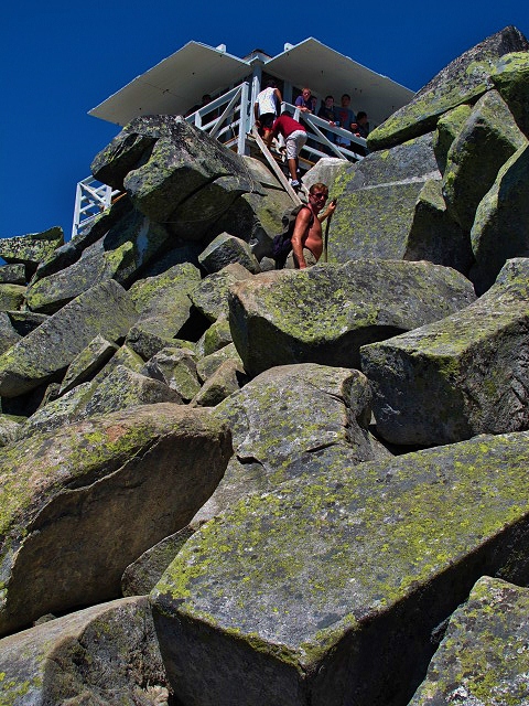
 Mount Pilchuck Fire Lookout August 2012

Click here for more photos of the Mount Pilchuck Trail.

The Mount Pilchuck Trail offers interesting terrain & sweeping vistas.  There are great slabs of granite resting on the slopes of the mountain like so many toppled dominoes.  The flora is not particularly exciting.  I found this trail to be fairly difficult: steep, crowded with hikers & strewn with sharp rocks.  There was snow on parts of the trail in August.  I slipped & fell on my back.  However, there were people of every age & description on the trail.  I was utterly amazed to see one man hiking barefoot.  At the very top of the mountain, you must climb over large boulders (& around the people climbing down) to get to the old fire lookout.  You can see forever from up there.  I'm not sorry I did this hike.  But I don't ever want to do it again.  The trail starts at 3,100 feet in elevation & climbs to the summit at 5,324 feet (1,623 meters).  It is 5.4 miles round trip.  The road to the trail head can be found off the Mountain Loop Highway in Snohomish County, Washington.

Friday, January 24, 2014

Heather Lake Trail

Heather Lake July 2012 

Avalanche at Heather Lake July 2012

Pedicularis groenlandica (Elephant's Head) at Heather Lake July 2012

Heather Lake July 2012

Lilium columbianum (Tiger Lily) at Heather Lake July 2012

Click here to see more photos of the Heather Lake Trail.

Although the forest along the Heather Lake Trail is varied & lovely, the amazing natural garden contained in the glacial cirque surrounding Heather Lake is truly amazing.  At the end of July, the last patches of snow were melting.  Some plants were just emerging from the ground.  Wildflowers were blooming everywhere.  At midsummer, it was spring recapitulated.  It was the most beautiful, diverse & abundant collection of flora I had seen in the Cascade Mountains.  The broken trees & piles of snow that remained from several avalanches were also quite interesting.  The Heather Lake Trail was easily the most impressive of the 10 hikes I made along the Mountain Loop Highway during the summer of 2012.  This trail starts at 1,400 feet in elevation & climbs to 2,500 feet (800 meters) in the subalpine zone.  It is 4.6 miles round trip, not a particularly difficult hike.

Friday, December 27, 2013

Middle Fork Snoqualmie River Trail

Middle Fork Snoqualmie River July 2012

Oplopanax horridus (Devil's Club) Middle Fork Snoqualmie River Trail July 2012

Hylocomium splendens (Step Moss) Middle Fork Snoqualmie River Trail July 2012

Middle Fork Snoqualmie River Trail July 2012

Dingford Creek Bridge, Middle Fork Snoqualmie River Trail July 2012

Click here for more pictures of the Middle Fork Snoqualmie River Trail.

The Middle Fork Snoqualmie River Trail follows the river very closely through the Mt Baker-Snoqualmie National Forest northeast of North Bend in King County.  Even though this is a recently disturbed, definitely not old growth forest, it is still quite beautiful.  The land is moist & lush.  The flora is varied & abundant.  The understory here is much more interesting than the trees.  The sight & sound of the river are constant companions.  There are often views of nearby mountains.  The elevation gain is only a few hundred feet, starting at about 1,000 feet above sea level.  It is possible to connect to other trails & continue hiking into steeper country for many miles.  About 4 miles from the trail head is a large & sturdy bridge crossing the roaring falls of Dingford Creek.  This is where I turned back.

Friday, November 22, 2013

Lake 22 Trail

Rubus parviflorus (Thimbleberry) Lake 22 Trail June 2012

Aruncus dioicus (Goat's Beard) Lake 22 Trail June 2012

Lake 22 June 2012

Veratrum viride (Corn Lily) Lake 22 Trail June 2012

 Lake 22 June 2012

Click here for more photos of the Lake 22 Trail.

The Lake 22 Trail is a fairly easy & spectacular hike in the Cascade Mountains in the Mt Baker-Snoqualmie National Forest in Snohomish County, Washington.  It is also a popular hike, with many people on the trail on summer weekends.  The trail head is on the Mountain Loop Highway, 13 miles east of Granite Falls.  The hike is mostly through lush, old growth forest, although some time is spent crossing a large, open talus slope with lovely views of nearby mountains.  The volume & diversity of the flora is truly amazing.  The trail starts at elevation 1,050 feet & ends at elevation 2,400 feet (731 meters) in the beautiful basin that contains Lake 22.  If you have any breath left at the top of the trail, your 1st view of the lake will take it away.  The hike is 5.4 miles round trip.