Friday, March 20, 2020

Toronto Waterfront or Harbourfront

Harbour Plaza Residences (65 and 69 story condominium towers) at center of photo


The CN Tower (at center right) is Toronto's most well-known landmark.


Photos taken in October 2017

To access the Toronto Waterfront, also called Harbourfront, requires passing under the monstrously ugly Gardiner Expressway, completed in 1963. We had our own eyesore, elevated highway in my hometown of Seattle, the Alaskan Way Viaduct, along the waterfront from 1953 until its demolition in 2019. They were & are still common in many US cities. Gardiner Expressway has been the subject of several proposals to demolish it as part of downtown waterfront revitalization efforts. I hope that happens.

The first thing I noticed about the Toronto Waterfront was the many residential towers as high as 70 floors. They were both impressive & overwhelming. The next thing I noticed was the string of parks along the water. Some were grassy & some had trees, while others were paved with concrete & boardwalk, or covered in sand. There were restaurants, shops, art galleries, water taxis & rental canoes. The waterfront was very interesting & dynamic. It had certainly been beautified, even if was not entirely beautiful. I enjoyed it.

More about the Waterfront
Harbourfront is the area along the Toronto waterfront extending from Bathurst Street to Yonge Street along Queens Quay. Its northern boundary is the Gardiner Expressway. Federal government lands to the south of Queen's Quay include a community center, Toronto Fire Department station, various boating uses, parkland & Harbourfront Centre. To the north of Queen's Quay, all of the industrial lands along the street have been replaced with condominium towers.

Harbourfront Centre, filled with galleries & performance spaces, is located at the foot of Lower Simcoe Street. There are 4 craft studios: ceramics, glass, metal and textiles. The studios began in 1974, providing new craft artists with subsidized work spaces at the beginning of their careers. Harbourfront hosts arts & cultural events every summer, including craft fairs, theater & dance performances, & concerts. Queen's Quay Terminal, next to Harbourfront Centre, is a former warehouse converted into a mixed-use building including stores & restaurants, commercial office space & condominiums.

Some History of the Waterfront
Toronto's harbor was used from the beginning of settlement for shipping & industry. The Town of York was founded west of the Don River, along the waterfront. At that time, the water's edge was where Front Street is now located. The shallow waters of Lake Ontario south of Front Street were covered with landfill, creating piers & room for industrial development.

The Harbourfront project was announced in 1972. It used industrial port lands from York Street west to Bathurst Street, south of Queen's Quay to create a cultural & residential district similar to the Granville Island in Vancouver. The federal government converted industrial land to an area with art galleries, performance spaces, boating areas & parks. The surrounding neighborhood was converted from industrial use to condominium towers by private developers.

There was a major reconstruction of Queen's Quay beginning in 2012. Two car lanes south of the streetcar tracks were eliminated between Spadina Avenue & York Street to extend Harbourfront parkland to the edge of the streetcar tracks. The Martin Goodman Trail (a bicycle path), two rows of trees, benches & a wider pedestrian space were installed there.

Friday, March 6, 2020

Toronto Architectural Juxtapositions


Historic Yonge Street Heritage Conservation District

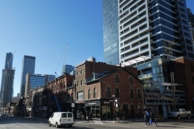
Yonge Street. See this modern high-rise below at full height.

Yonge Street with heritage buildings in foreground

Yonge Street with heritage buildings in foreground

Bathurst Street at Bloor Street.  The 2 brick buildings at left (793 & 795 Bathurst) are on the Heritage Register. B-streets Condos at right (783 Bathurst) has added 195 units on 8 floors to the Bloor Annex/Koreatown area.

Church Street in the Gay Village with heritage buildings in foreground. Photos taken in October 2017.

Toronto's construction boom of the 2010s has led to some startling architectural juxtapositions.  The huge difference in heights made me wonder about zoning & city planning in Toronto.  This doesn't happen in my hometown of Seattle.  I've rarely seen it in other cities.  It has happened in Toronto due to a combination of high population growth, the protection of older buildings under the Ontario Heritage Act, & the Official Plan for land use promoting greater density from high-rise residential buildings within the historic urban core.   

Toronto has designated 4,500 buildings under the Ontario Heritage Act. (Seattle has designated only 439 buildings as landmarks subject to protection by city ordinance.)  There are a large number of buildings on the Heritage Register fronting Yonge Street, while the properties just behind them are not preserved from development. Both sides of Yonge Street from Bloor Street to Carlton Street were in the process of becoming a Heritage Conservation District in 2017 when I was there.

Population Growth & Density
No other city in North America has added so many high-rise buildings as Toronto during the 2010s. The building boom was a response to historically low levels of development after the last major wave of the 1990s. Many of the new towers were condominiums, reflecting the growing appeal of inner city living, which offers easy access to work public transit. The city hurtled skyward in this decade, with 65 new condo towers completed in 2016 alone. From 2010 to 2017, more than 250,000 condo units were built.

The Greater Toronto Area was one of the fastest growing regions in North America in the 2010s due  mainly to immigration. Statistics from the 2011 census showed that Toronto increased by 9.2 per cent from the previous census in 2006. The challenge in the housing market was supply rather than demand & many buyers found it difficult to find a home. Policy-makers & many others favored "intensification" as a more sustainable & appealing alternative to sprawl. At less than half the density of New York City, Toronto had room for increased residential density. Toronto’s official plan designated about 85% of the city as small scale residential. Downtown areas where transit, parks & services were already established, were able to accommodate intensification most readily.

Land Use Changes
The Official Plan for Toronto sought to reduce reliance on cars by fostering a denser, environmentally sustainable, & more transit-oriented urban realm. The over-arching goal was re-urbanization, a reversal of the expanding suburban sprawl throughout much of the 20th century. The Official Plan identified specific areas where new commercial & residential growth should be encouraged, stipulating that new development should facilitate transit use & pedestrian activity. The Plan also mandated new protections for architectural heritage.

The most conspicuous element of the Official Plan was the creation of high-rise development areas. Increased density throughout downtown Toronto was strongly encouraged, with developers facing fewer legal & bureaucratic roadblocks to high-rise development in the urban core. Together with the robust real estate market, a cultural shift towards urban living, low interest rates, & decreased development charges, the Official Plan helped facilitate Toronto’s downtown construction surge.

Another important element of the Official Plan was an increased emphasis on protecting architectural heritage, & ensuring that new development fit into the urban context around it, including maintaining the visibility of heritage buildings. For most of the 20th century, heritage architecture was destroyed without much regard to its socio-cultural value. Before the Official Plan was enacted, municipalities had little power to prevent the demolition of older buildings. By expanding the Heritage Register & adding new provisions to protect the urban context around these buildings, the Plan provided legal criteria for the designation & maintenance of heritage properties. These policies made the destruction of heritage properties much more difficult.

Heritage Buildings Preservation
Heritage Conservation Districts protect & manage change within historic neighborhoods to maintain their heritage value & character. They reflect the historic significance & community heritage values of an area. They are evaluated by heritage professionals, planners, urban designers & archaeologists, sometimes with the help of volunteers & community members. They contribute to quality of life & the Toronto’s competitive edge, reinforce identity, create self awareness & promote social cohesion. They have history & character that contribute to a strong sense of place. They are an important tool for creating a high-growth environment.

Every potential Heritage Conservation District is evaluated by a set of criteria to determine if it demonstrates cultural heritage value. The Criteria are: The district has design value or physical value; The district has historical value or associative value; The district has contextual value; The district has social value or community value; The district has natural value or scientific value. If an area meets any one of these criteria, it is considered significant, however most Heritage Conservation Districts meet more than one criterion.