Friday, June 27, 2014

Pinnacle Lake Trail

Bear Lake on the Pinnacle Lake Trail September 2012 

Oplopanax horridus (Devil's Club) & Tsuga heterophylla (Western Hemlock) Pinnacle Lake Trail September 2012 

Cladothamnus pyroliflorus (Copperbush) Pinnacle Lake Trail September 2012 

Mountain tarn on the Pinnacle Lake Trail September 2012  

Pinnacle Lake September 2012

Click here to see more photos of the Pinnacle Lake Trail.

The Pinnacle Lake Trail takes you through a beautiful forest to the subalpine zone near Mount Pilchuck on the Mountain Loop Highway in Snohomish County.  The flora & terrain are both very interesting here.  It is mucky & grassy in the subalpine zone.  This is quite a contrast to the nearby Ashland Lake Trail, which ends in a wet environment filled with trees & bog plants.  The difference must be that Pinnacle Lake is 800 feet higher in elevation.  The trail was in poor condition in September 2012.  It was rocky & filled with the roots of huge trees.  It is also steep.  Pinnacle Lake itself is fairly small & not exceptionally beautiful.  The smaller tarn, in the same narrow cleft that contains Pinnacle Lake, is much more charming.  Bear Lake, near the start of the trail, is also pleasing.  The trail starts at 2,700 feet in elevation & climbs to 3,800 feet (1,158 meters).  It is 3.8 miles round trip.  

Friday, June 20, 2014

Rainier Beach Playfield


 Dunlap Elementary School

Rainier Beach Playfield in October 2013

Playfields are not very exciting places, unless you are actually playing a rousing game of soccer, football, baseball or softball.  But a large expanse of mowed lawn is restful to the eye & promotes a feeling of tranquility.  The Rainier Beach Playfield is particularly attractive, because it is in the secluded center of a super-block, surrounded by large old trees & the appealing architecture of the handsome brick Dunlap Elementary School, built in 1924 & the sleekly modern Rainier Beach Community Center, built in 2013.  Two other schools of unexceptional architecture are also here, South Lake High School & South Shore K-8 School.  Dunlap Elementary School honors Joseph Dunlap, the first white settler of Rainier Beach who built a home on the site in the 1870s. The Dunlaps donated the school site in 1904 to replace the 1898 log cabin school house.  The Rainier Beach Playfield can be found at 8802 Rainier Avenue S, a short walk from the Rainier Beach Station.  

Rainier Beach is located in the southeast corner of Seattle on the shore of Lake Washington. The Rainier Beach neighborhood includes the Dunlap neighborhood, which lies just west, between Rainier Beach & Beacon Hill. Joseph Dunlap built a cabin at S Henderson Street & 50th Avenue S. He brought his family from Iowa by wagon over the Oregon Trail in September 1869. Between the Dunlap claim and the lake was a low swampy area called Dunlap Slough. Those who settled south of the Dunlaps & close to the lake called their community Rainier Beach.  This information comes from Seattle Neighborhoods: Rainier Beach at HistoryLink.org.

Friday, June 13, 2014

May in Seattle

Kniphofia (Torch Lily) & Iris sibirica (Siberian Iris)

Wisteria

Weigela florida

Rubus parviflorus (Thimbleberry) This beautiful native plant with edible fruits deserves greater use in residential landscapes.

All photos were taken in the Montlake neighborhood in May 2014.

May 2014 in Seattle was significantly warmer & wetter than normal.  The mean temperature was 59.1F/15.06C.  The normal mean temperature is 56F/13.33C.  Total precipitation was 3.15 inches/80.01mm.  Normal precipitation is 1.94 inches/49.28mm.  The highest temperature was 85F/29.44C on 5/1, the lowest was 45F/7.22C on 5/7, 5/9 & 5/10.  Maximum daily temperatures were 60F/15.56C or more on every day of the month, 70F/21.1C or more on 9 days & 80F/26.67C or more on 4 days.  Temperatures in general were much more like June, than May.  There were 3 days with heavy rain, 4 days with rain, 11 days with light rain, 7 days with fog, 11 cloudy days, 16 partly cloudy days & 4 fair days.  Most of the rain fell at the beginning of the month.  There was only 0.37 inches/9.4mm after 5/10, while 2.14 inches/54.36mm fell from 5/3 through 5/5.

Friday, June 6, 2014

Kelcema Lake Trail

Kelcema Lake Trail in August 2013

Cornus canadensis (Bunchberry) in August 2013

Kelcema Lake Trail in August 2013

Kelcema Lake Trail in August 2013

Kelcema Lake in August 2013

Click here for more photos of the Kelcema Lake Trail.

The Kelcema Lake Trail is a short trail through sub-alpine forest off the Mountain Loop Highway in Snohomish County.  While the trail & lake are pretty enough, there are many more interesting & beautiful hikes in the immediate area.  Because you can drive on the forest service road to very nearly the level of the lake, this is an easy (1.2 mile round trip) walk for those not interested in, or able to do, a more strenuous hike.  Most of the short hikes off the Mountain Loop Highway are at lower elevations.

Friday, May 30, 2014

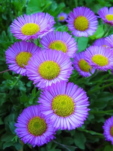
Erigeron speciosus

Erigeron speciosus 'Darkest of All' in the Ornamental Border at Bradner Gardens Park in June 2013

 
 Erigeron speciosus 'Prosperity' in the Cascadia Garden in June 2010
 
Erigeron glaucus in the Cascadia Garden in June 2012

Erigeron species at Frenchman Coulee near Vantage WA in May 2013 

Erigeron species at Crab Creek near Moses Lake WA in May 2013

This is a post about Erigeron speciosus & High Country Gardens.  Erigeron speciosus (Showy Fleabane) is a perennial with beautiful flowers, widespread in the western US, including Washington.  There are quite a number of cultivars & hybrids in various shades of blue, lavender & pink.  It grows to a height of about 30 inches.  It is a low maintenance & fairly drought tolerant plant.  While I'm at it, I'll also mention Erigeron glaucus & Erigeron in general. I think Erigeron glaucus is the most beautiful & useful species of the genus in Seattle.  It blooms for a very extended period from May through October & is highly drought tolerant.  The flowers are as large as Erigeron speciosus, but the plant is low & spreading.  The genus Erigeron has almost 400 species growing in a variety of conditions throughout the northern hemisphere.  Eastern Washington has a number of small species adapted to very dry conditions.  Two of them appear above.

In January of 2014, I received this message via email: I noticed a photo of Erigeron 'Darkest of All' on the blog The Ornamental Border at Bradner Gardens Park on July 6, 2013.  High Country Gardens is offering this plant for our Spring 2014 season and we are in need of a photo for our website.  We were wondering if you would allow us to use the photo.  If this is something you would  be willing to do we would be happy to send you a High Country Gardens gift certificate as a thank you.

I was happy to receive a gift certificate for $50, because I have high regard for High Country Gardens.  I ordered plants from them several times for the Cascadia Garden.  They were always in excellent condition.  High Country Gardens sells plants for the arid western US.  Many of their plants have limited use in Seattle.  But some are worth trying on dry sites, in pots filled partly with gravel, & under the overhangs on the south or west walls of buildings where they get a limited amount of rainfall.  Others, like Erigeron speciosus, grow well along the Pacific northwest coast.

Friday, May 23, 2014

Big Four Ice Caves Trail

Big Four Ice Caves Trail August 2012

Crossing the South Fork Stillaguamish River on the Big Four Ice Caves Trail August 2012

Avalanche area along the Big Four Ice Caves Trail August 2012

Big Four Ice Caves August 2012

 Epilobium angustifolium (Fireweed) Big Four Ice Caves Trail August 2012

Click here for more photos of the Big Four Ice Caves Trail.

The Big Four Ice Caves Trail is the Disneyland attraction of the Mountain Loop Highway.  There is a huge parking lot & a wide, smooth, handicapped-accessible trail.  Views of the surrounding mountains are spectacular.  The trail does not lead directly to the ice caves, but to a scenic overlook.  The ice caves are dangerous.  People have been injured, trapped inside the caves & even killed by falling ice.  Nevertheless, you will see many people walking inside & on top of the caves.  The caves generally form in the ice field at the foot of Big Four Mountain & remain visible until August.  According to local legend, Big Four Mountain was named after 4 husky brothers who lived in a cabin at the foot of the mountain. The trail starts at 1,700 feet in elevation & climbs gently to 1,900 feet (579 meters).  The hike is 2.2 miles round trip.

Friday, May 16, 2014

Tukwila International Boulevard Station

From the level of the tracks, you can see the foothills of the Cascade Mountains.


Tukwila International Boulevard Station in May 2014

Tukwila International Boulevard Station is a bold element in the suburban landscape in the City of Tukwila.  I think it's the most dramatic & interesting station along Seattle's single light rail line from Downtown Seattle to the Seattle Tacoma International Airport in  the City of SeaTac.  It is one of 3 elevated stations & the only station with a parking lot.  Designed by architect David Hewitt of Seattle, the station opened in July 2009 & was the southern terminus until December 2009, when the SeaTac/Airport Station opened.  The angle of the roof is meant to suggest airplanes, liftoff, the idea of elevation, the slope & wings of airplanes.  The control tower of the Seattle Tacoma International Airport is visible from the station, across State Route 518 leading to the airport.  There are also views of Mt Baker to the north & the Cascade Mountains to the east.  A small business district along Tukwila International Boulevard is near the station.  The City of Tukwila is a pleasant, racially &ethnically diverse, middle-income suburb of 19,000 people in 10 square miles, bordering the southern city limits of the City of Seattle.

Friday, May 9, 2014

April in Seattle


Leschi on April 28, 2014.


Kubota Garden on April 28, 2014.

April 2014 in Seattle was warmer & wetter than normal, which caused more vigorous growth of plants & more abundant flowers than normal.  The mean temperature was 52F/11.11C.  The normal mean temperature is 50.3F/10.17C.  Total precipitation was 4.18 inches/106.17mm.  Normal precipitation is 2.71 inches/68.83mm.  The highest temperature was 82F/27.78C on 4/30, which was very unusual.  Seattle averages only 25 days each year over 80F/26.67C & they usually come during the summer.  The lowest temperature was 40F/4.44C on 4/28.  There were 2 days with heavy rain, 8 days with rain, 14 days with light rain, 10 foggy days, 13 cloudy days, 16 partly cloudy days & 1 fair day.

Friday, May 2, 2014

East of the Mountains

East of the mountains is, for me, another county. It could not be more different than the land west of the Cascades. It has an austere beauty, a severe climate with little rain & a relentless sun. I went there on the 1st weekend in May of 2013 in a borrowed car.  East of the Mountains is also a novel by David Guterson.  I recommend it.

Crab Creek May 2013

I arrived at the Crab Creek trailhead in the Columbia NationalWildlife Refuge at 3 on Saturday. A sign told me rattlesnakes are common & protected.  They bite when they were provoked or startled. As I was still pondering how not to startle a snake (Should I shout out some sort of greeting?) I heard the rattle in the grass very near my feet. I bolted. Then every rustle of grass in the wind made me jump. I was walking through thick vegetation along the creek on a trail that was lost or overgrown in places. There were sagebrush, many grasses & huge areas of shrubby hawthorn.

Erigeron (Fleabane) at Crab Creek May 2013

I came to a broken-down stair of railroad ties that climbed out of the creek bed & onto the sparsely furnished plateau. The views, the wildflowers & the land were beautiful there. It would be very easy to spot a snake.  It was also very windy.  My hat blew off my head & down the cliff.  I climbed down to retrieve.  I hoped the path I had taken along the top of the low basalt cliffs would lead me back to the trailhead without passing through the area of the snake. But the trail, perhaps created by animals, became more & more sketchy, then disappeared. 

 Crab Creek May 2013

I cautiously retraced my route, whistling loudly. Another rattlesnake crossed my past less than 3 feet ahead of me. They are much less threatening when in transit, the rattle trailing mutely behind. When I reached the car, I found that the rear window had been smashed to pieces. Already unnerved by the snakes, I found this act of violence very disturbing. I had never driven with a window missing. I wondered whether I would be sucked out of the car driving 70 mph, or stopped by the highway patrol & left to walk back to Seattle. 

Phlox speciosa at Crab Creek May 2013 

Nothing happened on the way to Moses Lake. I asked the woman at the motel for the number of the police. I knew she was going to ask me why. The officer was not familiar with the location. 'You gotta help me out here,' he said. I felt this was ironic considering the distance I had traveled & the fact that he was stationed less than 20 miles from the incident. I mentioned that I thought I might need to make a report for insurance purposes. 'You don't gotta file an accident report, because there was no accident,' he said. No, I thought, it was very much on purpose. He said he would pass the information on to the rangers. I tried to call Rusty & Steve. I spoke with Dale & my mother.

If you ever need to eat in Moses Lake, go to Michael's Market & Bistro. 

Phlox & Achillea (Yarrow) at Gloyd Seeps Wildlife Area May 2013

I didn't sleep well & woke early. I drove a short distance to the Gloyd Seeps Wildlife Area. Near the parking lot, it was flat & dotted with stunted sagebrush. Perhaps the land had once been cleared for a field. There was agricultural land all around. The abandoned 4-wheel drive track that the Washington Trails Association website told me to follow for 3 miles ended in a cleared field in about ¼ mile. There was no sign of snakes & quite a number of wildflowers: large mats of phlox, with fleabane, larkspur, lupine & yarrow scattered about. But still, I was disappointed. 

While I was eating breakfast at Somebody's Family Restaurant, my mother called. She said I had to cover the window with plastic or risk carbon monoxide poisoning. 'I don't have any plastic,' I said. ' Keep your windows down & if you feel sleepy, get out of the car,' she advised. I did feel sleepy, because I hadn't slept well.  I kept thinking about carbon monoxide. 

Frenchman Coulee May 2013 

When I got near Vantage, on the Columbia River, I exited Interstate 90 on the spur of the moment. I had been down that road to Frenchman Coulee with Rusty a few years before. It was the highlight of the trip. The rugged scenery & abundant wildflowers were just what I needed.

Erigeron (Fleabane) at Frenchman Coulee May 2013

Lewisia rediviva (Bitterroot) at Frenchman Coulee May 2013

Balsamorhiza sagittata (Arrowleaf Balsamroot) & Artemisia tridentata (Sagebrush) at Frenchman Coulee May 2013

Frenchman Coulee May 2013