Friday, July 25, 2014

South Fork Sauk River


South Fork Sauk River September 2012

The South Fork Sauk River runs along the Mountain Loop Highway in the Cascade Mountains of Snohomish County, Washington.  This is the most scenic stretch of the highway, with views of the tumbling rapids & huge boulders within the river in a very extended waterfall.  There are many places to stop and access the river, but no designated picnic areas.  Stop for a look, or take your picnic down to one of the boulders along the river bank.  It's a magical experience.

Friday, July 18, 2014

Hillside Garden P-Patch


The Route 8 bus stops here.


Martin Luther King Jr Way S. All photos are of the Hillside Garden P-Patch in July 2013

The Hillside Garden P-Patch is one of the most visible community gardens in Seattle.  Terraced upward from the very bottom of the west slope of Mt Baker Ridge, this garden lies along busy Martin Luther King Jr Way S near S McClellan Street.  The gardeners here are all tenants of the Mt Baker Housing Association, which provides low-income housing in a small campus above the garden.  Many of the residents have been southeast Asian immigrants & refugees.  They began terracing & gardening the slope independently, after their arrival in the late 1970s.  The garden became a p-patch under the supervision of the Seattle Department of Neighborhoods in 2001.  Concrete retaining walls were added & plumbing installed.  There are 38 plots on 8,000 square feet, with plenty of space to expand.  The land is owned by the Seattle Fleets & Facilities Department.

Friday, July 11, 2014

June in Seattle


A Little Free Library which are popping up all over Seattle.

All photos were taken on Beacon Hill in June 2014.

June in Seattle was warmer & much drier than normal.  The mean temperature was 62F/16.7C.  The normal mean temperature is 60.9F/16.1C.  Total precipitation was 0.73 inches/18.54mm.  Normal precipitation is 1.57 inches/39.88mm.  The highest temperature was 79F/26.1C on 6/25, the lowest was 48F/8.9C on 6/16.  There was 1 day with rain, 12 days with light rain, 8 days with fog (2 of them with visibility at less than 1/4 mile) 14 cloudy days, 15 partly cloudy days & 1 fair day.  Seattleites enjoyed 2 of their largest festivals at the end of June: the Fremont Fair 6/20-22, which included the Fremont Solstice Parade on 6/21 & Seattle PrideFest 6/28-29 (the 40th gay pride celebration in Seattle) with over 100,000 people attending.

Friday, July 4, 2014

Sidewalk Gardens on 30th Avenue S

Choisya ternata 'Aztec Pearl' (Mexican Orange) & a lot more.

Persicaria microcephala 'Red Dragon' (Knotweed) with Anthriscus sylvestris 'Raven's Wing' (Wild Chervil) behind it.

Hosta, of course.

Choisya ternata 'Sundance' (Mexican Orange) & Clematis 'Jackmanii'

This garden path leads off from the sidewalk.

Berberis thunbergii 'Crimson Pygmy' & Yucca filamentosa.  Photos taken in May 2014.

I've noticed that sidewalk gardens tend to proliferate in certain blocks.  While many blocks have no sidewalk gardens, just lawn & maybe street trees, other blocks have several extensive plantings near the sidewalk & between the sidewalk & the street.  This particular block of 30th Avenue S, on Mt Baker Ridge near Bradner Gardens Park, has at least 5 sidewalk gardens adjacent & directly across the street.  This is certainly a boon to passersby.  The pictures above belong to 3 of these gardens.  Not all of this is what the Seattle Department of Transportation would like to see done in the parking strip.  They insist that plants be kept to no more than 3 feet in height for visibility & traffic safety.  (Trees are the exception to this rule, but require permits.)  In my opinion, it is better to plant shrubs that don't grow much more than 3 feet tall, especially on a corner, where they will certainly block views of traffic. 

Friday, June 27, 2014

Pinnacle Lake Trail

Bear Lake on the Pinnacle Lake Trail September 2012 

Oplopanax horridus (Devil's Club) & Tsuga heterophylla (Western Hemlock) Pinnacle Lake Trail September 2012 

Cladothamnus pyroliflorus (Copperbush) Pinnacle Lake Trail September 2012 

Mountain tarn on the Pinnacle Lake Trail September 2012  

Pinnacle Lake September 2012

Click here to see more photos of the Pinnacle Lake Trail.

The Pinnacle Lake Trail takes you through a beautiful forest to the subalpine zone near Mount Pilchuck on the Mountain Loop Highway in Snohomish County.  The flora & terrain are both very interesting here.  It is mucky & grassy in the subalpine zone.  This is quite a contrast to the nearby Ashland Lake Trail, which ends in a wet environment filled with trees & bog plants.  The difference must be that Pinnacle Lake is 800 feet higher in elevation.  The trail was in poor condition in September 2012.  It was rocky & filled with the roots of huge trees.  It is also steep.  Pinnacle Lake itself is fairly small & not exceptionally beautiful.  The smaller tarn, in the same narrow cleft that contains Pinnacle Lake, is much more charming.  Bear Lake, near the start of the trail, is also pleasing.  The trail starts at 2,700 feet in elevation & climbs to 3,800 feet (1,158 meters).  It is 3.8 miles round trip.  

Friday, June 20, 2014

Rainier Beach Playfield


 Dunlap Elementary School

Rainier Beach Playfield in October 2013

Playfields are not very exciting places, unless you are actually playing a rousing game of soccer, football, baseball or softball.  But a large expanse of mowed lawn is restful to the eye & promotes a feeling of tranquility.  The Rainier Beach Playfield is particularly attractive, because it is in the secluded center of a super-block, surrounded by large old trees & the appealing architecture of the handsome brick Dunlap Elementary School, built in 1924 & the sleekly modern Rainier Beach Community Center, built in 2013.  Two other schools of unexceptional architecture are also here, South Lake High School & South Shore K-8 School.  Dunlap Elementary School honors Joseph Dunlap, the first white settler of Rainier Beach who built a home on the site in the 1870s. The Dunlaps donated the school site in 1904 to replace the 1898 log cabin school house.  The Rainier Beach Playfield can be found at 8802 Rainier Avenue S, a short walk from the Rainier Beach Station.  

Rainier Beach is located in the southeast corner of Seattle on the shore of Lake Washington. The Rainier Beach neighborhood includes the Dunlap neighborhood, which lies just west, between Rainier Beach & Beacon Hill. Joseph Dunlap built a cabin at S Henderson Street & 50th Avenue S. He brought his family from Iowa by wagon over the Oregon Trail in September 1869. Between the Dunlap claim and the lake was a low swampy area called Dunlap Slough. Those who settled south of the Dunlaps & close to the lake called their community Rainier Beach.  This information comes from Seattle Neighborhoods: Rainier Beach at HistoryLink.org.

Friday, June 13, 2014

May in Seattle

Kniphofia (Torch Lily) & Iris sibirica (Siberian Iris)

Wisteria

Weigela florida

Rubus parviflorus (Thimbleberry) This beautiful native plant with edible fruits deserves greater use in residential landscapes.

All photos were taken in the Montlake neighborhood in May 2014.

May 2014 in Seattle was significantly warmer & wetter than normal.  The mean temperature was 59.1F/15.06C.  The normal mean temperature is 56F/13.33C.  Total precipitation was 3.15 inches/80.01mm.  Normal precipitation is 1.94 inches/49.28mm.  The highest temperature was 85F/29.44C on 5/1, the lowest was 45F/7.22C on 5/7, 5/9 & 5/10.  Maximum daily temperatures were 60F/15.56C or more on every day of the month, 70F/21.1C or more on 9 days & 80F/26.67C or more on 4 days.  Temperatures in general were much more like June, than May.  There were 3 days with heavy rain, 4 days with rain, 11 days with light rain, 7 days with fog, 11 cloudy days, 16 partly cloudy days & 4 fair days.  Most of the rain fell at the beginning of the month.  There was only 0.37 inches/9.4mm after 5/10, while 2.14 inches/54.36mm fell from 5/3 through 5/5.

Friday, June 6, 2014

Kelcema Lake Trail

Kelcema Lake Trail in August 2013

Cornus canadensis (Bunchberry) in August 2013

Kelcema Lake Trail in August 2013

Kelcema Lake Trail in August 2013

Kelcema Lake in August 2013

Click here for more photos of the Kelcema Lake Trail.

The Kelcema Lake Trail is a short trail through sub-alpine forest off the Mountain Loop Highway in Snohomish County.  While the trail & lake are pretty enough, there are many more interesting & beautiful hikes in the immediate area.  Because you can drive on the forest service road to very nearly the level of the lake, this is an easy (1.2 mile round trip) walk for those not interested in, or able to do, a more strenuous hike.  Most of the short hikes off the Mountain Loop Highway are at lower elevations.

Friday, May 30, 2014

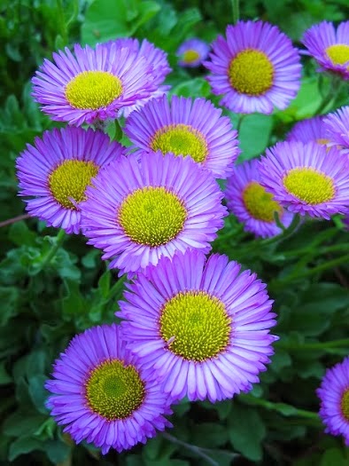
Erigeron speciosus

Erigeron speciosus 'Darkest of All' in the Ornamental Border at Bradner Gardens Park in June 2013

 
 Erigeron speciosus 'Prosperity' in the Cascadia Garden in June 2010
 
Erigeron glaucus in the Cascadia Garden in June 2012

Erigeron species at Frenchman Coulee near Vantage WA in May 2013 

Erigeron species at Crab Creek near Moses Lake WA in May 2013

This is a post about Erigeron speciosus & High Country Gardens.  Erigeron speciosus (Showy Fleabane) is a perennial with beautiful flowers, widespread in the western US, including Washington.  There are quite a number of cultivars & hybrids in various shades of blue, lavender & pink.  It grows to a height of about 30 inches.  It is a low maintenance & fairly drought tolerant plant.  While I'm at it, I'll also mention Erigeron glaucus & Erigeron in general. I think Erigeron glaucus is the most beautiful & useful species of the genus in Seattle.  It blooms for a very extended period from May through October & is highly drought tolerant.  The flowers are as large as Erigeron speciosus, but the plant is low & spreading.  The genus Erigeron has almost 400 species growing in a variety of conditions throughout the northern hemisphere.  Eastern Washington has a number of small species adapted to very dry conditions.  Two of them appear above.

In January of 2014, I received this message via email: I noticed a photo of Erigeron 'Darkest of All' on the blog The Ornamental Border at Bradner Gardens Park on July 6, 2013.  High Country Gardens is offering this plant for our Spring 2014 season and we are in need of a photo for our website.  We were wondering if you would allow us to use the photo.  If this is something you would  be willing to do we would be happy to send you a High Country Gardens gift certificate as a thank you.

I was happy to receive a gift certificate for $50, because I have high regard for High Country Gardens.  I ordered plants from them several times for the Cascadia Garden.  They were always in excellent condition.  High Country Gardens sells plants for the arid western US.  Many of their plants have limited use in Seattle.  But some are worth trying on dry sites, in pots filled partly with gravel, & under the overhangs on the south or west walls of buildings where they get a limited amount of rainfall.  Others, like Erigeron speciosus, grow well along the Pacific northwest coast.

Friday, May 23, 2014

Big Four Ice Caves Trail

Big Four Ice Caves Trail August 2012

Crossing the South Fork Stillaguamish River on the Big Four Ice Caves Trail August 2012

Avalanche area along the Big Four Ice Caves Trail August 2012

Big Four Ice Caves August 2012

 Epilobium angustifolium (Fireweed) Big Four Ice Caves Trail August 2012

Click here for more photos of the Big Four Ice Caves Trail.

The Big Four Ice Caves Trail is the Disneyland attraction of the Mountain Loop Highway.  There is a huge parking lot & a wide, smooth, handicapped-accessible trail.  Views of the surrounding mountains are spectacular.  The trail does not lead directly to the ice caves, but to a scenic overlook.  The ice caves are dangerous.  People have been injured, trapped inside the caves & even killed by falling ice.  Nevertheless, you will see many people walking inside & on top of the caves.  The caves generally form in the ice field at the foot of Big Four Mountain & remain visible until August.  According to local legend, Big Four Mountain was named after 4 husky brothers who lived in a cabin at the foot of the mountain. The trail starts at 1,700 feet in elevation & climbs gently to 1,900 feet (579 meters).  The hike is 2.2 miles round trip.