Showing posts with label West Seattle. Show all posts

Friday, November 28, 2014

Lincoln Park

Lincoln Park October 2011

Lincoln Park October 2011

Lincoln Park October 2011

Lincoln Park October 2011

Arbutus menziesii (Madrona) in Lincoln Park October 2011

Lincoln Park is probably the most popular park in West Seattle.  It is one of the largest in Seattle at 135 acres.  It has a number of attractions including trails, picnic shelters, playing fields, views of Puget Sound, the Colman Pool & a long beach.  There are a number of old growth Douglas Fir (Pseudotsuga menziesii) at the top of the bluff in a park-like setting.  The most natural part of the park is the bluff, with fine specimens of Madrona (Arbutus menziesii) & the thin strip of beach with many large driftwood logs.  Unfortunately, the wide path between the bottom of the bluff & the beach, is paved in asphalt.  Lincoln Park is an interesting mix of nature & human development.  The most quirky elements are the Redwood (Sequoia sempervirens) groves in the upper area of the park.  Why were these trees planted & why so many?  Lincoln Park is located next to the Fauntleroy Ferry Terminal in the neighborhood of Fauntleroy.  The small Fauntleroy business district, with a few restaurants, is nearby. 

Friday, January 17, 2014

Alki Beach at Sunset

Landscaping along Alki Avenue SW.  Alki is a word from the Chinook Jargon meaning 'by and by'.  Seattle's first white (American) settlers landed here in 1851.

A diminutive Statue of Liberty.

Duwamish Head with the Space Needle beyond.

Puget Sound, the Kitsap Peninsula & the Olympic Mountains.

 Alki Beach Park.  All photos were taken in May 2013.

Alki Beach Park is located at Alki Beach, on Elliott Bay, on Puget Sound, in West Seattle.  This is probably the most popular salt-water beach park in the City of Seattle.  It is especially crowded on warm summer days & evenings, when people picnic on the imported sand, play volleyball & walk on the promenade.  Puget Sound beaches are mostly rocky.  The pathway extends from Alki Point, past Duwanish Head to the Duwamish Waterway.  Few people swim, since Puget Sound is perpetually cold, never exceeding 56F/13C, even in summer.  In spring & fall, there are walkers, bicyclists & skate boarders.  It can be especially charming at sunset, as the light fades behind the Olympic Mountains.  There are a number of restaurants across from the beach along Alki Avenue SW.  Views include the Kitsap & Olympic peninsulas, Downtown Seattle, Queen Anne Hill & Magnolia Bluff.

Friday, November 15, 2013

Belvedere Park

 View from Belvedere Park October 2011

View from Belvedere Park October 2011

View from Belvedere Park October 2011

 
Belvedere Park October 2011

There isn't much to Belvedere Park except the view.  But what an excellent view it is!  There is a sweeping vista of Downtown Seattle across Elliott Bay from this park on the east edge of the Admiral District of West Seattle.  You can also see Queen Anne Hill, 1st Hill, Beacon Hill & Harbor Island.  The park covers 1.7 acres on both sides of SW Admiral Way.  The totem pole was carved from a cedar log cut from nearby Schmitz Preserve Park, another wonderful Seattle park you must visit on your tour of West Seattle.  Below Schmitz Preserve Park is Alki Beach, Seattle's most popular waterfront promenade.  You can easily walk between Schmitz Park & Alki Beach.  The business districts of the Admiral District & Alki are filled with shops & restaurants.

Friday, October 18, 2013

Schmitz Preserve Park

 Pseudotsuga menziesii (Douglas Fir) & Thuja plicata (Western Red Cedar) in Schmitz Preserve Park October 2011

Acer macrophyllum (Bigleaf Maple) in Schmitz Preserve Park October 2011

 Polypodium glycyrrhiza (Licorice Fern) in Schmitz Preserve Park October 2011

Blechnum spicant (Deer Fern) in Schmitz Preserve Park October 2011

 
SW Admiral Way Bridge over Schmitz Preserve Park October 2011

Schmitz Preserve Park in West Seattle is a natural wonder.  It covers 53 acres in a ravine filled with old growth forest, creeks, trails & a multitude of native plants.  Unfortunately, the Inaugural Day Storm of 1993 blew down several of the remaining old growth trees in the park, leaving precious few.  A larger old growth forest (120 acres) exists in Seward Park & some old growth trees can be found in Lincoln Park in a more park-like setting.  Schmitz Preserve was donated to the city in pieces between 1908 & 1912. The largest portion (30 acres) came from Ferdinand Schmitz, who served on the park commission at that time. It was Schmitz's idea to preserve part of the rapidly disappearing forest in its natural state.  Additions to the park were purchased in 1930, 1947, and 1958.  From the park, it is possible to walk down the ravine, past Schmitz Park Elementary School, through the Alki Playground to the Alki business district & Alki Beach Park.

Friday, March 1, 2013

High Point Commons Park P-Patch

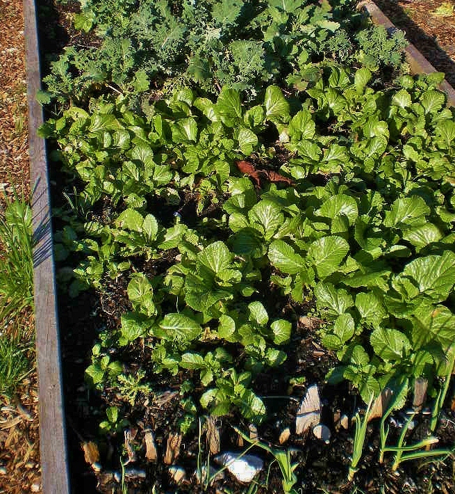
High Point Commons Park P-Patch February 2013

The shed at the High Point Commons Park P-Patch February 2013

High Point Commons Park P-Patch February 2013

High Point Commons Park P-Patch February 2013

High Point Commons Park P-Patch February 2013

The High Point Commons Park P-Patch is located in the High Point development at SW Graham Street & 32nd Avenue SW.  It is a small & fairly new community garden.  High Point redevelopment began in 2006. High Point Commons Park is the largest open space in the development.  The p-patch is located at the north end along SW Graham Street.  Unlike the other p-patches I have visited, there is no information about it at the Seattle Department of Neighborhoods website, although it is listed as a public housing site with priority given to residents.  A young woman walking her dog nearby told me that I should see the p-patch during the summer. She described its bounty.  I said it looked good in winter.  She said she & her mother had a plot there.  High Point is a mixed-income community with approximately 1,600 housing units, about half of them low-income rentals owned by the Seattle Housing Authority. The other half are single family homes, condominiums & town homes sold to private owners.  As of February 2013, private homes are still being built.   

Friday, February 15, 2013

High Point Natural Drainage System

High Point Natural Drainage System February 2013. Storm water is stored in this large, permanent pond before it empties into Longfellow Creek.

High Point Natural Drainage System February 2013. A cut in the curb allows water from the street to flow into a swale.

High Point Natural Drainage System February 2013. Nearly all the parking strips at High Point have been built as swales.

High Point Natural Drainage System February 2013. A small temporary retention pond.

High Point Natural Drainage System February 2013. A drain at the bottom of a swale.

Because of its size & relationship to Longfellow Creek, the redevelopment of High Point in West Seattle offered Seattle Public Utilities an opportunity to contruct a large natural drainage system, the largest built by the City of Seattle & the first natural drainage system of this scale used in a high-density Seattle neighborhood. Designed in partnership with the Seattle Housing Authority, the system treats about 10 percent of the watershed feeding Longfellow Creek, which flows into the Duwamish River, then Puget Sound. The natural drainage system mimics nature by using swales to capture & naturally filter storm water. Landscaped ponds hold the overflow. All 34 blocks of the High Point community are part of this system. In addition, porous surfaces make up a significant part of the sidewalks & parking spaces. 

High Point was originally developed during World War II to provide government housing. It remained a district of predominantly low-income housing through the 1990s. In 2003, the Seattle Housing Authority began work on the first phase of a 6-year project to redevelop High Point into a mixed-income community. All existing housing, roads & utilities were replaced. High Point now has approximately 1,600 housing units, about half of them low-income rentals owned by the Seattle Housing Authority. The other half are single family homes, condominiums & town homes sold to private owners. 

The need to improve the water quality of Longfellow Creek drove the plan to connect High Point with the surrounding environment. The City of Seattle is required by the US Environmental Protection Agency to dramatically cut sewage overflows by 2025. Natural drainage systems are an effective method for curbing storm water, which can trigger overflows of raw sewage. The swales & temporary retention ponds (also known as rain gardens) are planted with red-twig dogwood, evergreen huckleberry, sword fern, grasses, sedges & other plants. Rainwater soaks into the ground rather than flowing into the (unfortunately combined) storm water & sewer system. Oil, pesticides & other pollutants are filtered out to decompose & be consumed by micro-organisms in the soil.  Not long after a heavy rainfall, swales & shallow ponds are mostly empty of water.  Before flowing on to Longfellow Creek, water is stored in a large pond, often used by migratory waterfowl, located at the lower edge of the development. Following the path of the water through High Point is a pleasant & interesting walk.