Showing posts with label nature. Show all posts

Friday, September 4, 2020

Oak Grove Regional Park Stockton


Photos taken in April 2018

Click here for more photos of Oak Grove Regional Park.

After breakfast at the motel in Sacramento, we drove to Oak Grove Regional Park in Stockton. We walked in the oak grove for almost 2 hours. There were dozens of large, old valley oaks (Quercus lobata). The trees were larger than any oak I’d seen in California before. The ground was covered with grasses & a few shrubs such as elderberry (Sambucus). We saw Canada geese, hawks & ground squirrels. Although there is housing development surrounding the park & infrastructure within the park, I didn't notice much but the oaks, the grass & the hawks high in the sky above.

Oak Grove Regional Park, between Stockton & Lodi (4520 West Eight Mile Road, Stockton) has an area of 180 acres. Two nature trails provide a 1.5 mile walk in the grove: the Yokuts Trail & the Miwok Trail. The shorter Yokuts Trail features native plants.  The much longer Miwok Trail winds through the oak grove. Oak Grove Nature Center focuses on wildlife, habitats & the native inhabitants of the area: the Miwok & Yokuts peoples. Oak Grove Regional Park is one of very few woodlands remaining in the California Central Valley.

Native Americans lived in the Central Valley for thousands of years before the town of Stockton was built. When Europeans arrived, they found the Yatchicumne, a group of Northern Valley Yokuts people, living in the Stockton area. The Yokuts built their villages on low mounds to avoid the regular flooding. A Yokuts village was located on a mound in what is now downtown Stockton. The number of Yokuts, whose settlements stretched 250 miles from the confluence of the Sacramento & San Joaquin rivers to the Tehachapi Mountains, is estimated at 18,000 to 50,000. They gathered acorns & ground Tule reeds into meal.  The reeds were also used to make baskets & mats that covered their dwellings. The Miwok inhabited lands to the north.  

The number of Native Americans in the San Joaquin Valley began to dwindle after their first contact the Spanish arrived in 1769.  Between 1805 & 1825, Franciscan priests persuaded many of them to move to the Santa Clara, San Jose, San Juan Batista & San Antonio missions. Those missions were mostly abandoned after an epidemic in 1833 killed 75% of the native population. During the Gold Rush of 1848, American settlers forced the remaining Yokuts from their lands.

The San Joaquin & Sacramento valleys join where the Sacramento & San Joaquin Rivers flow through Carquinez Strait to San Francisco Bay. Stockton lies at the southern edge of the the Sacramento Delta at the confluence of the San Joaquin & Calaveras Rivers. The Central Valley is an elongated depression (430 long & 75 miles wide) between the Coast Ranges & the Sierra Nevada. At its center, east of San Francisco Bay, it is slightly below sea level. The Central Valley is 2 joined valleys: the Sacramento Valley, drained by the Sacramento River & the San Joaquin Valley, drained by the San Joaquin River. The confluence of these two rivers forms the Sacramento-San Joaquin Delta, formerly a massive wetland, now a major agricultural area.

The Central Valley contained 3 primary communities of plants & animals: Valley Grassland, Freshwater Marsh, & Riparian Woodland. Woodlands grew in the Delta & along the rivers. In the mid-1800s, woodlands covered about a million acres of the Central Valley. Today they cover only about 100,000 acres. The disappearance of woodland is attributed to overgrazing by domestic animals beginning with cattle & sheep introduced by the Spanish & continued by American settlers.  Woodland trees include Western Sycamore (Platanus racemosa), Box Elder (Acer negundo) Fremont Cottonwood (Populus fremontii) & 3 species of willow. The most impressive tree is the Valley Oak (Quercus lobata).

Friday, August 21, 2020

Merced Wild and Scenic River


Cercis occidentalis (Western Redbud)


Cercis occidentalis (Western Redbud)


Photos taken in April 2018

Click here for more photos of Merced Wild and Scenic River.

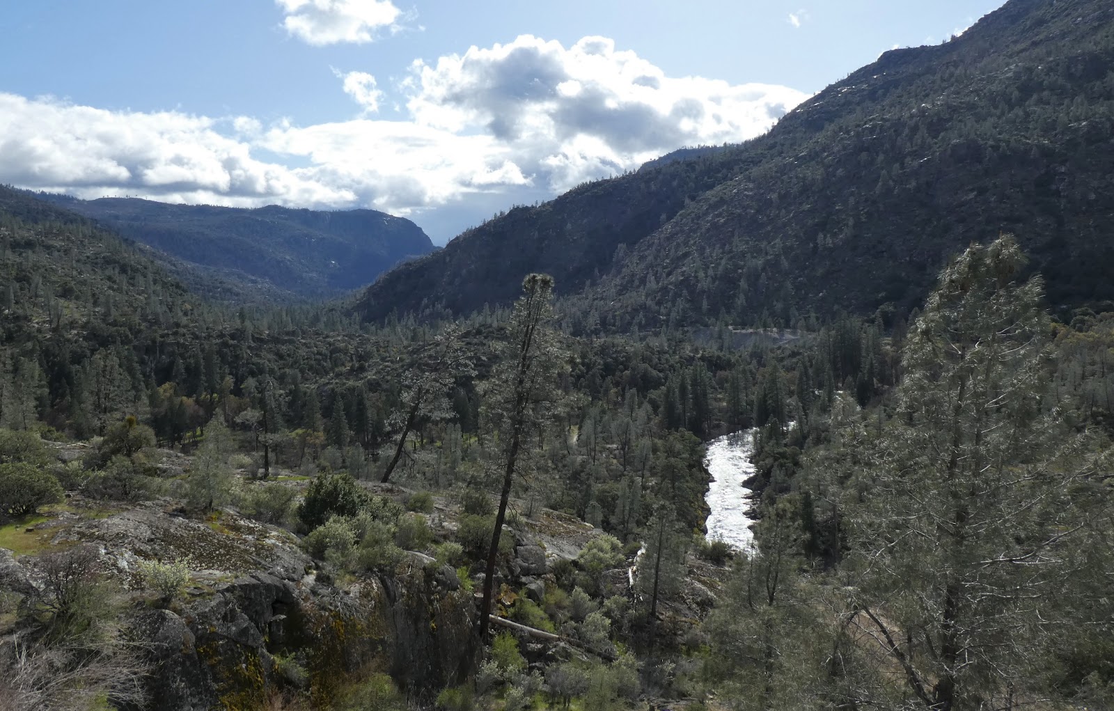
From our resort near Yosemite National Park, we drove a few miles up HWY 140 to the Merced River Trail. I loved it. The river was beautiful & the banks were filled with an abundance of plants, vibrant with new growth & many flowers. I was fascinated by the California native plants I had studied in landscape design school in San Francisco. The weather was cool & partly cloudy. We walked for 3 hours on a dirt road with no cars 

The Merced is designated a wild & scenic river under the Wild & Scenic Rivers Act of 1968 by the US Congress. It is one of 11 wild & scenic rivers in California. There is a variety of native, endemic &/or rare plant species along the river with many small meadows & riparian habitats. The river begins high in the Sierra Nevada Mountains. It flows through Yosemite National Park & on to the Sacramento Valley where it joins the San Joaquin River. 8 miles of the lower Merced River from Briceburg downstream to Bagby (near Yosemite National Park) received wild & scenic status in 1992.  3 of those miles are wild, the only wild (most pristine) segment outside Yosemite National Park. That section of the river ends when it joins lake McClure above Bagby. 

The Merced River along Highway 140 (outside the park) is designated recreational. This segment of the river provides access to the free-flowing river & makes HWY 140 the most scenic route into Yosemite National Park. We had easy access to walk along this part of the river by turning off HWY 140 at Briceburg Rd, crossing a suspension bridge, parking in a small lot near the river & the highway 16 miles below the Arch Rock Entrance to Yosemite National Park.

Friday, August 7, 2020

Hetch Hetchy Valley

Hetch Hetchy Valley below the dam

O'Shaughnessy Dam

Water flowing from the dam

Hetch Hetchy Reservoir (more than 300 feet deep)

Digger pine cone (Pinus sabiniana)

South rim of the valley above the dam. Photos taken in April 2018

Click here for more photos of Hetch Hetchy Valley.

Our last day in Yosemite National Park was April 12, 2018. After walking in Tuolumne Grove, we took a lovely drive to Hetch Hetchy Valley.  It was beautiful. We couldn’t walk in the valley, because it is filled with a reservoir that provides the San Francisco Bay Area with water. But we could see it from above & from the top of the impressive dam. The Hetch Hetchy Road runs down to the dam, near the western edge of park.  The reservoir fills the valley to the east for 8 miles.

The valley was even more beautiful before the dam was built. The bottom of the valley had 1,200 acres of meadows surrounded by a forest of pine, oak & Douglas fir. The Tuolumne River & many streams flowed through the valley, while stands of alder, willow & dogwood grew among them. More than 300 feet of the valley walls had not yet been covered by water.

Work on the Hetch Hetchy Project began in 1914 when the Hetch Hetchy Railroad (68 miles long) was built to bring construction materials to the dam site. It was dismantled in 1949. Construction of O'Shaughnessy Dam began in 1919 & ended in 1923. The height of the dam was increased from 227 to 312 feet in 1938. The aqueduct system brought water to San Francisco in 1934 after flowing 167 miles from Hetch Hetchy Valley.

San Francisco was granted water rights to Hetch Hetchy Valley by the United States Department of the Interior in 1908.  The Sierra Club (led by John Muir) began a campaign to stop the project.  National opinion was divided between damming & preserving Hetch Hetchy Valley. Conservationists felt the environment should be used in a "conscientious manner" to benefit society.  Preservationists believed that nature should be preserved & protected. San Francisco argued that the reservoir was vital to the city. John Muir asked Congress to protect Hetch Hetchy Valley from destruction. Hundreds of individuals & organizations sent petitions to Congress. It was the beginning of the American environmentalist movement.

Because the valley was in Yosemite National Park, an act of Congress was required. The Raker Act was passed in 1913 & signed by President Woodrow Wilson. It permitted the flooding of the valley, but stipulated that power & water could only be used for public interests.

In 1921, Principal Jessie Lockwood was asked to select a new name for the York School that had opened in 1910 in the Mt Baker neighborhood of Seattle. She chose John Muir. Part of her motivation for selecting Muir was the hope that students would develop a love of nature & a desire to conserve natural beauty.  Ironically, I attended that school for 7 years, but learned nothing about John Muir or environmentalism during that time.

Friday, July 17, 2020

Tuolumne Grove Yosemite National Park


Photos taken in April 2018

Click here for more photos of Tuolumne Grove.

On 4/12/18, we drove to Tuolumne Grove at an elevation of 6,000 feet. It was cold, but not quite freezing & covered with a thin layer of snow. The forest was magnificent. The giant sequoias (Sequoiadendron giganteum) were huge & amazing. I’d never seen a tree anywhere near that large before. Even coast redwoods (Sequoia sempervirens) aren’t that big. The pines were also much larger than any pine I’d ever seen. It was truly an ancient forest. We walked on a trail that was partly covered with snow. The distance was about 2.5 miles round trip. Tuolumne Grove is one of  3 giant sequoia groves in Yosemite National Park. It contains more than 20 mature giant sequoia trees in the midst of a lush coniferous forest also including pine, fir & dogwood.

Giant sequoia are the most massive trees in the world.  Some have grown to 300 feet with diameters of 56 feet near the base. A range of 160 to 270 feet in height with trunk diameters of 20 to 26 feet is more common. The oldest tree is more than 3,000 years old. They can produce as many as 11,000 cones & disperse more than 300,000 seeds annually.  Giant sequoias grow in the western Sierra Nevada. They are scattered among 68 groves that cover less than 36,000 acres.  They grow at elevations averaging 5,600 feet in the north & 6,300 in the south of their range, mostly on southern slopes in the north & northern slopes in the south.

Giant sequoia were discovered by Europeans in 1833. Logging began in the 1850's & removed a third of the big trees. A preservation effort started in 1864 & increased in 1890 with creation of  Yosemite National Park & Sequoia National Park.  Giant sequoia can be found in Seattle parks & gardens.  They are easy to grow, but require a lot of space.

Friday, July 3, 2020

Yosemite Valley

El Capitan

Half Dome


Mirror Lake

Half Dome

Merced River

Photos taken in April 2018

Click here for more photos of Yosemite Valley.

After spending the night in Modesto, we drove to Yosemite National Park. The foothills of the Sierra Nevada were beautiful. We stopped along a rural road just inside Mariposa County to take photos. We stopped again in the small town of Mariposa to buy groceries, some of which we ate for lunch. The drive along the mountain roads was lovely with many manzanitas & redbuds in bloom.

Yosemite Valley was disappointing. It was smaller than we expected by half: the valley half as wide, the mountains half as tall. It was less impressive than many other mountain valleys we had seen in the Cascades & Rockies. I kept thinking of the very tall & impressive Teton Mountains in Wyoming. It was the first time we had seen the Sierra Nevada, where the mountains are taller than the Cascades. We usually see the Cascades from a much lower elevation. The elevation of Yosemite Valley is 4,000 feet/1,200 meters. It makes sense that the mountains wouldn’t be very much higher than that.

It’s a fairly narrow valley. There are lots of trees that obscure views of the mountains. And there have been many forest fires in Yosemite National Park & the surrounding national forests. The dead & blackened trees were disturbing. The ground was trampled by millions of tourists. Yosemite is the most visited national park in the US. The area around the Majestic Yosemite Hotel (formerly the Ahwahnee Hotel) built in 1927, was like a small city. The ground was covered with cabins, tent cabins, employee apartments, stores, roads & parking lots. It did not feel close to nature.

Our friend was irritated by our attitude. I tried to joke when I pulled out my camera & said, "I'll just have to work with what we’ve got here." Although she laughed, that irritated her even more. She has an annual pass & comes to Yosemite several times a year. It takes 2.5 hours to drive from Modesto. She suggested we walk on the trail to Mirror Lake. That was much better. We walked on an asphalt road that had been closed to cars. The forest plants were less damaged by foot traffic. There were beautiful & impressive views across the lake to mountains including the famous Half Dome.

Friday, December 6, 2019

Huron National Forest Corsair Trail

Arctostaphylos uva-ursi (kinnikinnick or bearberry) has a circumboreal distribution, growing around the world in northern latitudes.

Pinus banksiana (jack pine) predominates on more than one million acres of forest in Michigan.

Vaccinium vitis-idaea (Lingonberry) is also circumboreally distributed.

Quercus (oak). There are a dozen species of oak in Michigan.  Quercus alba (white oak) & Quercus rubra (red oak) are most common in this area.

Pantherophis vulpinus (eastern fox snake) is found in the upper Midwestern United States, east of the Mississippi river.

Pinus banksiana (jack pine)

The Lumberman's Monument.  Photos taken in October 2017

Click here for more photos of the Corsair Trail.

In the Huron National Forest, we hiked the Corsair Trail for 2.5 hours. The forest was very quiet & stunningly beautiful. It was filled mostly with pine & oak trees, plus many understory plants. The forest was replanted by the Civilian Conservation Corps during the Great Depression of the 1930s, helping it recover from the devastation of the timber industry from 1870 to 1900. I saw many plants I recognized & a few that also grow in Washington. I had bought a field manual of Michigan flora before I left Seattle, but it was too big to carry with me.  I almost stepped on a fox snake, which then lay motionless on the trail. After we finished the hike, we drove to the Lumberman’s Monument, where we saw interpretive displays about logging & lumberjacks. The Corsair Trail system has 28 miles of trail that varies from gently rolling to somewhat hilly terrain. The system was developed primarily for cross-country skiing.  But the trails may be hiked anytime during the snow-free periods.

Friday, November 15, 2019

Pinconning Nature Preserve


Photos taken in October 2017

Click here for more photos of Pinconning Nature Preserve.

In October 2017, we drove up the shore of Saginaw Bay (Lake Huron) on Michigan highway M-13 to Pinconning Nature Preserve. It was quick & easy to access the preserve from the highway at the small City of Pinconning along E Pinconning Road. We walked on a pleasant trail through a small forest to a wetland on the bank of the Pinconning River. We were unable to go far into the wetland, let alone to the river, because the trail became too wet & mucky. But it was pretty there on that small preserve, which had once been a farm.  My advice is to wear big rubber boots.

The preserve has a variety of plant communities including lowland deciduous forest, scrub/shrub, & marsh. In addition to wetlands, there is 2,165 feet of frontage on the Pinconning River.  The complete loop trail is a little over 1 mile.  The preserve is owned & maintained by the Saginaw Basin Land Conservancy. Headquartered in Bay City, the SBLC owns and maintains 10 nature preserves that are open to the public, dawn until dusk, every day of the year, forever. They are natural areas in need of protection & management for the ecological benefits they provide to people & the environment. Some land was purchased through partnerships, while other properties were donated outright, or donated while reserving the right to live on & use the property. When the landowner dies, the Saginaw Basin Land Conservancy takes title & control over the property.

Friday, January 5, 2018

Red Rock Canyon National Conservation Area

The White Hills

Arctostaphylos pungens (Manzanita) & the La Madre Mountains

Agave utahensis

Pinyon-Juniper Woodland 

Pinus monophylla (Single-leaf Pinyon)

Red Rock Canyon beyond the woodland

Yucca schidigera


On the last Friday in January 2016, we went to Red Rock Canyon National Conservation Area. We hiked more than 6 miles around the White Rock Hills on the White Rock Loop Trail.  In the canyon between the hills & the La Madre Mountains, there was a Pinyon-Juniper Woodland. We saw quite a variety of plants. There were manzanita & a dozen other shrubs, 6 species of cactus as well as 2 species of Yucca & also Agave utahensis. The climb up through the canyon gave spectacular views & wasn’t difficult. The descent into Red Rock Valley was less interesting & the last 2 miles, along the lower edge of the White Rock Hills, through desert scrub, was exhausting. We hiked for almost 4 hours & never stopped to rest.