Showing posts with label urban landscape. Show all posts

Friday, April 23, 2021

West Seattle Junction/Alaska Junction, Seattle


Photos taken in May 2018

West Seattle Junction, Alaska Junction, or the Junction are the names used for the business district centered on the intersection of California Ave SW & SW Alaska St. The Junction is downtown West Seattle. But people call most of this area, "the Junction." The heart of the Junction is the 3 blocks on either side of California Ave SW from SW Genesee St to SW Edmunds. It developed at the intersection of California Ave SW & SW Alaska St, when two streetcar lines connected there in 1907.  Now it's a lively business district with restaurants, chain stores, supermarkets, veterinary clinics & many small specialty shops. 

Most of the older commercial buildings are 1-floor, like of the surrounding post-war houses. By 2020, West Seattle's population had grown to 80K. A number of 6-floor residential buildings invaded the business district & there were more than 70 businesses listed in the area. The Junction is geographically connected to many other businesses along Fauntleroy Way SW from SW Alaska St to 35th Ave SW. The eastern part of this sprawling business district is contained by the Genesee neighborhood that also surrounds the Junction. While many neighborhoods & business districts have well-established names, the City of Seattle sets no official boundaries.

In the near future, according to Sound Transit: The West Seattle Link Extension will provide fast, reliable light rail connection to dense residential & job centers throughout the region. A new downtown Seattle light-rail tunnel will add capacity for the entire regional system to operate efficiently. The West Seattle Link Extension adds 4.7 miles of light rail service from downtown Seattle to West Seattle Junction/Alaska Junction. There will be 4 new stations between SODO & the Junction. This is part of the regional transit system expansion approved by voters in 2016.

West Seattle Junction was swamp & forest until April 1907, when two streetcar lines intersected at California Avenue SW & SW Alaska Street. It soon became known as the Junction. Lots in the area sold quickly. By 1911, the Junction had become a business district with 3 grocery stores, 2 lumber companies, a hardware store, & 3 physicians, among other businesses. The dirt streets were lined with wooden structures of one floor. By 1920, the Junction had replaced the Admiral District as the largest commercial district in West Seattle. Older buildings were demolished & new ones were constructed at a rapid rate, some for the national retail chains Piggly Wiggly, Ernst Hardware, J. C. Penney, & F. W. Woolworth. The Spanish-style Granada movie theater opened in 1926 with 1,000 seats.

Seattle began removing streetcars in 1940, replacing them with buses. The Junction’s first traffic lights were installed in 1943. The West Seattle Bridge opened in 1984.  Jefferson Square (a 6-storey complex of stores, apartments & lots of parking) opened in 1987. It's main tenants were Bartell Drugs & Safeway. After that, there was a decline in businesses in the Junction. In 1994, the Seattle City Council Comprehensive Plan was adopted for business districts across the city. Growth was planned for urban villages in large, multi-floor residential buildings with ground-floor retail. By the end of the 1990s, new businesses had opened, including Capers, Elliott Bay Brewing, & ArtsWest Playhouse. The West Seattle Farmers' Market began operating in 1999.


Friday, January 8, 2021

Pioneer Square Seattle


The Pioneer Square Pergola was built in 1909 as cable car stop. In January 2001, the iron & glass structure collapsed when it was hit by a truck. It was replaced in August 2002.

The Pioneer Building was completed in 1892. 4 photos above taken in January 2014

King Street Station was built in 1904-06. The clocktower was inspired by St Mark's Campanile in Venice. Photo taken in June 2017


3 photos above taken in December 2017

Click here for more photos of Pioneer Square.

Pioneer Square is one of my favorite places in Seattle.  It's popular with Seattleites & also a popular tourist attraction.  Many people live & work there.  Shops & restaurants cater to locals more than to tourists, even during the short tourist season.  Pioneer Square's derelict period ended many years ago.  It is now more urban chic.      

The area now called Pioneer Square became Seattle's first permanent American settlement in 1852. It was the only sizable piece of level ground on Elliott Bay.  It developed quickly into a residential & business district of wooden buildings.  Those were all destroyed in the Great Fire of 1889.  It was quickly rebuilt as the central business district by 1892 with brick & stone buildings in the Richardsonian Romanesque style popular in the United States from 1885 to 1905. Pioneer Square has one of the best surviving collections of Richardsonian Romanesque commercial architecture in the US & became a National Historic District in 1970.  An interesting feature of Pioneer Square is the Seattle Underground which can be explored in the Underground Tour. Because the area was built on low ground, high tides sometimes filled the streets, which were raised by one level.  That turned the former 1st floors into basements with front doors, windows, signage & sidewalks still intact. 

Pioneer Square peaked during the Klondike Gold Rush (1896-99) then fell into decline. By the 1920s, it was seen as the southern part of downtown, rather than Seattle’s main commercial center. It became a district of taverns & seedy hotels. The city government reversed that decline when it named Pioneer Square Preservation District as Seattle's first such district in May 1970. The Pioneer Square-Skid Road Historic District was listed in the National Register of Historic Places in June 1970. The neighborhood takes its name from a small triangular plaza near the corner of First Ave & Yesler Way, originally known as Pioneer Place. Yesler Way was known as "skid road" during the early days of settlement when logs were skidded down the steeply sloping road to the Yesler Sawmill located on Elliott Bay. It is the likely origin of the term "skid row" from the seedy period of Pioneer Square.

Significant structures & sites in Pioneer Square: 

Grand Central Building 216 1st Avenue S: It was built in 1889-90 as an office building & converted to the Grand Central Hotel during the Klondike Gold Rush in 1897.  It was renovated 1971 as an office building with the Grand Central Bakery (established 1972) & other shops on the ground level.

King Street Station 303 South Jackson St: It was built in 1904-06 by the Great Northern Railway & Northern Pacific Railway.  It was most recently renovated in 2013, restoring its original fixtures. Inside the main entry, at the base of the clock tower, is the main hall, known as the Compass Room. Its ceiling resembles one at the Palazzo Vecchio in Florence.  It is served by 3 Amtrak routes & commuter trains run by Sound Transit.

Klondike Gold Rush National Historical Park
319 2nd Ave S: A museum located in the Cadillac Hotel, an 1889 building that was a major point of outfitting & departure during the gold rush.

Merchants Cafe 109 Yesler Way: Seattle's oldest restaurant opened in 1890.

Occidental Square 117 S Washington St: A 0.6 acre public park located between the 19th-century Grand Central Building & the 21st-century Weyerhaeuser Company Headquarters.  In summer, it's filled with park furniture, bocce courts, ping pong tables, occasional festivals & crafts markets.

Pioneer Building 600 1st Ave: One of the most impressive of the historic structures in Pioneer Square, it was built in 1889-92.  It is 94 feet tall with a beautiful facade.  It was listed as a National Historic Landmark in 1977.  It stands behind the Pioneer Square Pergola & totem pole.  You can buy tickets for the Seattle Underground Tour there. It was built as & remains an office building.

Pioneer Square Pergola at 1st Avenue & Yesler Way: The small park also includes a totem pole & plaza with benches in front of the Pioneer Building.

Smith Tower 506 2nd Ave: The oldest skyscraper in the city (38 floors) was built 1911-14.  It was the tallest building on the West Coast until 1962.  Designated as a Seattle landmark in 1984, it is a lofty example of neoclassical architecture.  The surface is granite to the 2rd floor, then gleaming white terracotta from the 3rd floor on up. The observation deck near the top has a 360-degree view of 
downtown, SoDo, Elliott Bay & more.

Union Station 401 S Jackson St: Built in 1910-11, 3 train lines used this station until 1971.  Then it was unused until an expansive renovation was finished in 1999.  The renovation won the 2000 National Historic Preservation Award. The beautiful Great Hall is open to the public during business hours.  Union Station is now the headquarters of Sound Transit.

UPS Waterfall Garden Park 2nd Ave & Main St: The small private park was created in 1978 at the site of the original UPS (United Parcel Service) building.  It is open to the public during the day.  The Japanese-style garden has a 22-foot tall waterfall flowing at 5,000 gallons per minute.  It is one of the most expensive parks per square foot built in the US.


Friday, November 6, 2020

Old Sacramento


Steel Bridge, a local landmark seen from Old Sacramento Waterfront. Photos taken in April 2018.

Click here for more photos of Old Sacramento.

From my travel journal on 4-9-18: We flew to Sacramento from Seattle & arrived before 11 AM. We rented a car. We drove to Robert Matsui Waterfront Park. The causeway to the modern, architecturally striking water intake structure was closed, but we could see it clearly from the riverbank. The Sacramento River was high from heavy rain 3 days before. Trees along the riverbank were standing in water. We drove a short distance to Old Sacramento, also on the Sacramento River Waterfront. It was a very charming area filled with shops & restaurants in wooden 19th century buildings, older than any in Seattle. It had an "Old West" feel with covered sidewalks of wooden boards.

Old Sacramento State Historic Park is a National Historic Landmark District. The City of Sacramento began at Sutter's Fort, more than 2 miles from the Sacramento River & more than 1 mile from the place Sutter's party landed on the south bank of the American River & established a camp in 1839. The settlers moved to Sutter's Fort in 1841. In 1848, gold was found during the construction of  a sawmill on the American River. People rushed to find gold & the fort was largely deserted by 1850. When the Gold Rush began, local merchant Sam Brannan opened a store near the Sacramento River. First called Sutter’s Embarcadero, it soon became the City of Sacramento. The city grew rapidly as a center for outfitting miners.

Old Sacramento Historic District covers the area between the river & Interstate 5, I St & the Capitol Mall.  It is a relatively small district of 8 short streets from 2 to 4 blocks long. Almost all the buildings date from the mid-19th century, beginning after the fire of 1852. After varying amounts restoration, they look much like they originally did. While the architecture is Victorian, some buildings have characteristics such as large arched doorways, full-height balcony windows & wrought-iron balconies that show a Spanish influence. The buildings are filled with restaurants, gift shops & other tourist businesses.  While the shops can be a bit tacky, the facades of the buildings & the district a whole seem quite authentic. Old Sacramento State Historic Park attracts over 5 million visitors annually.

Friday, October 16, 2020

Midtown Sacramento


Photos taken in April 2018

Click here for more photos of Midtown Sacramento.

From my travel journal on 4-13-18: We went for dinner at Jack’s Urban Eats in Midtown, then walked around that area & had gelato. There were several gay businesses there, but it was also the main business district for all of Midtown Sacramento: a large, vibrant commercial & residential area. There were many beautiful Victorian houses, some used as offices. There were a few large new apartment buildings similar to those in Seattle. There was a light rail system. We liked it very much. 4-14-18: At 7 AM, I walked for a mile from the motel, through Midtown, to the commercial area where we had been the night before. I took lots of photos. Our motel was at the edge of Midtown, which covers about 2 square miles. There was a street market that morning. I bought bread.

Midtown is the most attractive, interesting & vibrant neighborhood in Sacramento. It is adjacent to & east of Downtown.  It lies between R St & J St, 16th St & 30th St.  Most of the neighborhood is residential. The Victorian, Queen Anne & Craftsman homes are charming & mostly well-maintained. Midtown is Sacramento's main area for restaurants, bars, clubs, boutiques, art galleries & various small businesses.  They cluster between 18th & 21st, N & J streets & also spread east along J St to 27th St. The Midtown Farmers Market takes place year-round, every Saturday, on 20th St between J St & L St in the center of this business district. Sacramento's small LGBTQ entertainment district & community center is located nearby at K St & 20th St.

Starting around 1890, Sacramento began to spread east from 16th St to Alhambra Blvd. The J St & K St business corridors were extended from downtown. This area of mixed housing & business was later called Midtown. Buffalo Brewing started in 1890 at 21st St & Q St, the largest brewery west of the Mississippi. Sutter's Fort was restored & rebuilt from 1891 to 1893. It was designated a National Historic Landmark in 1961. Firehouse No. 3 was built in 1893 at 1215 19th St & listed on the National Register of Historic Places in 1991. Memorial Auditorium opened in 1927 at 15th St & J St. California Packing Corporation (CalPak) Plant #11 began operations in 1930 at 17th St & C St. Sutter Memorial Hospital opened in 1937 as Sutter Maternity Hospital at 29th St & Capitol Ave.

The Capitol Mansions Historic District is located in Midtown between 22nd St & 27th St, Kayak Alley (between Capitol Ave & L St) & Matsui Alley (between Capitol Ave & N St). It is a group of more than 150 large, stately structures that were originally single-family residences. The features, characteristics & materials of the structures are consistent with Queen Anne & Classic Box/Foursquare homes. The latter is a sub-type of Colonial Revival homes, built prior to 1915. More than 150 structures were listed when Capitol Mansions became a historic district in 2004.

Friday, May 15, 2020

Distillery District Toronto


Photos taken in October 2017

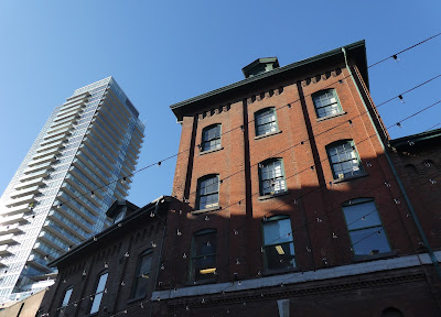
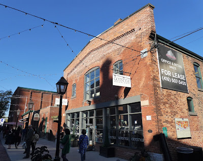
The Distillery District in Toronto is an amazing restoration & reuse of Victorian industrial buildings.  There are restaurants, and shops housed within heritage buildings of the former Gooderham and Worts Distillery. The district covers 13 acres with 36 Victorian buildings on 10 mostly pedestrian streets.  It is the largest collection of Victorian industrial architecture in North America. The district was designated a National Historic Site of Canada in 1988. It had been protected under the Ontario Heritage Act since 1976. Two high-rise condominium buildings were built at the edge of the district & cleverly incorporated into Victorian buildings in the late 1990s.  The Distillery District has been used as a location for over 800 film & TV productions. 

After years of decline, the distillery closed in 1990.  In 2001, the site was purchased & developed into the pedestrian-orientated area that now exists, opening in 2003. Buildings are occupied by shops, art galleries, restaurants, coffee houses, a brewery & a performing arts center. The upper floors of a number of buildings are leased to artists as studio spaces & to office tenants with a creative focus. Condominiums, office & retail space has been developed on nearby vacant land.

Friday, May 1, 2020

Riverdale Farm Toronto


Photos taken in October 2017

Riverdale Farm is at the east edge of Cabbagetown in Riverdale Park West. It's certainly worth a visit when you are touring charming Cabbagetown, particularly if you like animals. It contains heritage breeds of farm animals: cows, horses, sheep, goats & poultry.  Riverdale Farm covers 7.5 acres with several buildings & paddocks. There are also flower, vegetable & herb gardens. Riverdale Farm opened in 1978. The City of Toronto purchased the land that became Riverdale Park in 1856. Riverdale Zoo opened in 1894 on the site of Riverdale Farm & closed in 1974. The animals moved to the new Toronto Zoo. From 1974 to 1978, many of the Riverdale Zoo buildings were removed.

The larger barn (the Francey barn) was built in 1858 on a farm about 30 km away. It was donated to the City of Toronto in 1977 & rebuilt at Riverdale Farm. It has 2 levels. There is also a smaller pig & poultry barn. Both barns are located near the Simpson House at the entrance to Riverdale Farm. The Simpson House was built on site & designed to represent the 1850s Francy farmhouse where the Francey barn first existed. The Meeting House was built in 1993 by the duck pond. Activities are offered to the public inside & it includes a lost & found, first aid & restrooms. There are also 2 smaller houses built on the property in the early 20th century & used for various purposes.

Friday, April 17, 2020

Cabbagetown Toronto


There is a small business district along Parliament Street.


Photos taken in October 2017

I thought Cabbagetown was charming, with very well-preserved Victorian houses.  Each small front yard was full of shrubs & trees. Riverdale Farm is at the eastern edge of Cabbagetown in Riverdale Park.  Both are worth visiting in Toronto. Cabbagetown is the largest continuous area of preserved Victorian housing in North America, according to the Cabbagetown Preservation Association.  I lived in San Francisco (in 2 Victorian houses) & the area filled with Victorian architecture is much larger, although perhaps not perfectly continuous.  I was disappointed with the limited extent of Cabbagetown, but it was quite charming.

The extent of Victorian architecture was once much greater.  But the neighborhood deteriorated as housing aged & it became one of Toronto's largest slums.  Much of the original Cabbagetown was razed in the late 1940s & replaced with housing projects.  I walked through an area of public housing along Parliament Street. It wasn’t decrepit or threatening, but dull & bleak, like much of the architecture of that period. The construction of large housing projects ended in the 1970s, as Cabbagetown began to gentrify.  Houses there are quite expensive now.

Cabbagetown was first established in the 1840s, as a suburb of Toronto. Its main thoroughfares were Parliament Street & Winchester Street. At the east end of Winchester Street, Playter’s Bridge linked developing areas east of the Don River to Toronto. Cabbagetown developed along those streets. One of Toronto’s oldest cemeteries (the Necropolis) opened on Winchester Street in 1850.

When Irish immigrants settled in Cabbagetown in the 1840s & 1850s, they often planting vegetables (especially cabbages) on the land around their homes. Cabbagetown was a derisive name used to mock that practice. Cabbagetown began to deteriorate in the early 20th century. Most of  Cabbagetown had been built by 1900. Significant decline came before the Depression.

Friday, April 3, 2020

Graffiti Alley Toronto


Photos taken in October 2017

I walked up Spadina Avenue from the waterfront to Graffiti Alley in the Fashion District. That was quite a sight. There was a huge amount of artistic graffiti, more than I had ever seen in one place. People were in the alley taking photos, or on photo shoots. Artists were making graffiti. It was a lively scene, which continued out onto West Queen Street.

Graffiti art was first legalized in Graffiti Alley.  Legalization was promoted by the Queen Street West Business Improvement Association. Property owners in the area didn't want to be compelled by the city to remove graffiti art. The Business Improvement Association pointed to the cultural significance of Graffiti Alley & its popularity with tourists. All of Rush Lane south of Queen Street West from John Street to Bathurst Street was designated as an area of municipal significance in the Graffiti Management Plan adopted by Toronto City Council in 2011.

Graffiti art & graffiti vandalism are different things in Toronto. Individuals &  businesses must remove graffiti vandalism on their property.  Graffiti art is planned & does not need to be removed. The City of Toronto defines graffiti vandalism as "One or more letters, symbols, figures, etching, scratches, inscriptions, stains, or other markings that disfigure or deface a structure or thing, howsoever made or otherwise affixed on the structure or thing, but, for greater certainty, does not include an art mural." Graffiti art is a "mural for a designated surface and location that has been deliberately implemented for the purpose of beautifying the specific location."