Pages

Friday, February 28, 2014

Mount Pilchuck Trail

Mount Rainier from the Mount Pilchuck Trail August 2012

Mount Baker from the Mount Pilchuck Trail August 2012

Mount Pilchuck August 2012

Phyllodoce empetriformis (Pink Mountain-Heather) Mount Pilchuck Trail August 2012

 Mount Pilchuck Fire Lookout August 2012

Click here for more photos of the Mount Pilchuck Trail.

The Mount Pilchuck Trail offers interesting terrain & sweeping vistas.  There are great slabs of granite resting on the slopes of the mountain like so many toppled dominoes.  The flora is not particularly exciting.  I found this trail to be fairly difficult: steep, crowded with hikers & strewn with sharp rocks.  There was snow on parts of the trail in August.  I slipped & fell on my back.  However, there were people of every age & description on the trail.  I was utterly amazed to see one man hiking barefoot.  At the very top of the mountain, you must climb over large boulders (& around the people climbing down) to get to the old fire lookout.  You can see forever from up there.  I'm not sorry I did this hike.  But I don't ever want to do it again.  The trail starts at 3,100 feet in elevation & climbs to the summit at 5,324 feet (1,623 meters).  It is 5.4 miles round trip.  The road to the trail head can be found off the Mountain Loop Highway in Snohomish County, Washington.

Friday, February 21, 2014

John C Little Garden


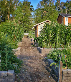
 John C Little Garden, with John C Little, Sr Park beyond, in August 2013

The John C Little Garden can be found at the north end of John C Little, Sr. Park, located in the New Holly development, at the south end of the Rainier Valley of Seattle.  John C Little, Sr. was a member of the Board of Park Commissioners who developed programs & services for disadvantaged youth & low-income families.  This modest & very rectilinear garden was established in 2013.  The land is owned by the Seattle Department of Parks & Recreation.

Friday, February 14, 2014

January in Seattle


The Smith Tower, a Seattle landmark completed in 1914.  It was the tallest building in Seattle until 1962, when the Space Needle was completed.

Witch Hazel (Hamamelis x intermedia) blooming in the Waterfall Garden.


The Pioneer Building, completed in 1892 & designated a National Historic Landmark in 1977.  All photos were taken in Pioneer Square on 1/15/14.  Some of Seattle's oldest buildings are here.  They date back to 1889, when a fire destroyed the wooden buildings that came before.  This was the original downtown Seattle.

January 2014 in Seattle was warmer & drier than usual.  The mean temperature was 44.3F/6.83C.  The normal mean temperature is 42F/5.56C.  The highest temperature was 58F/14.44C on 1/11, the lowest 31F/-0.56C on 1/5 & 1/6.  Total precipitation was 3.7 inches/93.9mm.  Normal precipitation is 5.57 inches/141.48mm.  This was the 4th month with significantly lower rainfall.  The Seattle Times published an article about the potential shortage in the municipal water supply, if this weather pattern persists.  There was 1 day with heavy rain, 9 days with rain, 15 days with light rain, 28 days with fog (17 with visibility at less than 1/4 mile) 22 cloudy days,  8 partly cloudy days & 1 fair day.  My mother said she had never seen so much fog.  I liked the fog.  But this January seemed very dark with so many cloudy days.

Friday, February 7, 2014

Jefferson Park


Jefferson Park February 2013. Jefferson Skatepark with Downtown Seattle skyline.


Jefferson Park February 2013. Skatepark, driving range & the Jefferson Park Golf Course.


Jefferson Park February 2013. Solar Picnic Shelter with solar panels rooftops were constructed by Seattle City Light.  
The playing field is used mostly for soccer & kirikiti (Samoan cricket).


Jefferson Park February 2013. View of Beacon Hill, Puget Sound & the Olympic Mountains.


Jefferson Park February 2013. Storm water retention pond.

Jefferson Park is the 6th largest park in the City of Seattle, covering 52 acres, including the golf course. It is located on Beacon Hill, at about 320 feet above sea level.  This is not the highest point in Seattle, but the views of the Olympic Mountains & Puget Sound from here are spectacular.  The park is adjacent to the Veterans Affairs Medical Center.

The City of Seattle purchased this land in 1898 for a reservoir & cemetery that were later sited elsewhere. The City named the park to honor Thomas Jefferson in 1908. The Jefferson Park Golf Course, Seattle’s oldest municipal golf course, opened for play in 1915. The area occupied by the golf course & adjacent park was part of the original Seattle park master plan developed by the Olmsted Brothers in 1903.  The golf course & the park roadway on the west side were built as planned. The northwest portion of the park site was transferred to the Water Department in 1935 for construction of a reservoir. The unused portion of the Water Department site was developed into a playground by permit with Seattle Parks and Recreation. During World War II, Jefferson Park contained anti-aircraft batteries, a military recreation center & tent housing for soldiers. The lawn bowling green was constructed in 1944.  It has been operated by the Jefferson Park Lawn Bowling Club under an agreement with Seattle Parks since 1945.

In the late 1990s, planning & design for more park improvements began. Seattle Public Utilities decommissioned the north reservoir & reconstructed the south reservoir as a buried reservoir with a hard cover. The 2000 Pro Parks Levy provided funding for improvements to the park. The new play area & tennis courts opened in 2010. The 2008 Parks and Green Spaces Levy funded additional improvements, including the Jefferson Park Skatepark, solar picnic shelters & the Jefferson Park Playfield, which opened in 2012.  Beacon Mountain, an ecologically oriented play area, opened in 2013.